Manassas National Battlefield Park Considered Threatened By Proposed Data Center

Manassas National Battlefield Park is considered one of Virginia's most endangered historic sites by Preservation Virginia/Kurt Repanshek file

A proposal to build a sprawling digital data center next to Manassas National Battlefield Park has landed the park on the 2022 list of Virginia's "Most Endangered Historic Places."

The listing by Preservation Virgina was spurred by a decision by local county officials to rezone land next to the Civil War battlefield for a "mega data center" complex that would impact the historic landscape just outside the park boundary.

"Locating data centers within technology corridors and away from culturally sensitive areas would convey how local governments value and support the preservation of their irreplaceable historic resources," the organization said in its annual list of endangered sites.

The digital data center planned to go in next to Manassas would cover more than 2,000 acres. Filmmaker Ken Burns has called the proposal the "single greatest threat to Manassas National Battlefield Park in nearly three decades."

The First Battle of Bull Run (First Manassas) was fought near Manassas, Virginia, on July 21, 1861. The Second Battle of Bull Run (Second Manassas) was fought over nearly the same ground during August 28-30, 1862. 

Back in 2008, Professor Emeritus Robert Janiskee wrote in the National Parks Traveler that concerns were growing over threats development posed to the battlefield.

The two battles commemorated at the 5,100-acre park, both Confederate victories, were fought less than 30 miles southwest of our nation’s capital in an area of northern Virginia that has experienced tremendous economic growth over the past few decades. Fast-growing Prince William and Fairfax counties are now so heavily developed that green space and large trees have become comparatively scarce in many areas. Locals fear that few mature trees will be left unless development is checked and strict tree protection ordinances are enforced. Another concern at Manassas and other Civil War battlefield parks is encroaching development that obscures historic sightlines. ... Some battlefield parks, such as Fredericksburg and & Spotsylvania National Military Park, are almost completely surrounded by development and exist as historic islands in a modern milieu. In such cases, historic sightlines extend only as far as the park boundary.

In reviewing the current proposal, Justin Patton, the Prince William County archaeologist, wrote that the project would "have a high potential to adversely affect cultural resources in the following forms: indirect effects such as Audio, and Visual; and direct effects in the destruction of the resource. Transportation improvements necessary to implement land use and zoning changes, will likely have an indirect and direct effects on our history as well."

In discussing her group's list of endangered historic sites, Preservation Virginia CEO Elizabeth S. Kostelny said the list "reflects the resilience of the Commonwealth's many historic places that have persisted for generations in support of their communities. The dedication of organizations, local governments, and individuals currently working to preserve these places reflects the very nature of the historic preservation movement- the ability to adapt to challenges and retain relevance in an ever-changing world."

The Virginia's Most Endangered Historic Places program has a track record of success. This past year, previously listed sites including Rassawek, historic capital of the Monacan Indian Nation, River Farm, headquarters of the American Horticultural Society, and the Warm Springs Bathhouses, the oldest spa site in the United States, were saved from insensitive development and neglect. Since the program began, more than 50 percent of sites listed have been saved, 10 percent were lost, and the remaining 40 percent are still being monitored.

Help Save 48 acres at Cedar Creek and Cedar Mountain

Combined, these 48 acres of hallowed ground at Cedar Creek and Cedar Mountain in Virginia have a transaction value of $939,153 — nearly $1 million. Thanks to a combination of state and federal grants and major gifts, each $1 you give will be multiplied by a factor of $29!  

The first tract of this preservation opportunity consists of 3 acres at Cedar Creek, in the Shenandoah Valley of Virginia, the site of the savage, bloody battle that Confederate and Federal troops both won and lost in the same day. Both sides saw victory and defeat within the same battle. It’s also one of the most threatened battlefields in America.

The second tract is 45 acres at Cedar Mountain, in the Virginia piedmont, where Confederate General Stonewall Jackson rode into the heart of the battle to rally his faltering troops ... and when his rusted saber refused to come out of the scabbard, Jackson wielded it, scabbard and all, to turn the tide of battle.

This land is also targeted by both residential and utility-scale solar developers — just imagine this piece of history lost forever, buried under modern, close-set, single-family houses or baking beneath endless rows of solar panels! 

Please help the American Battlefield Trust do that with your most generous gift right away. Remember, each $1 you give will be matched and will have the impact of an incredible $29 multiplier. 

Donate Now

Help Preserve 311 Acres Where Four Prominent Generals Fought

Unprotected battlefield land all across America has never been more threatened, it has never been more expensive, and the competition to buy it has never been more intense. We need your help today!

  Already this year, we have tremendous opportunities that simply cannot wait: four tracts of land available for purchase totaling 311 acres with a $13-to-$1 matching gift opportunity. We need to raise $206,207 to secure the land, and we need to do it within the next two months.

  Three of the four tracts will be “first acre” purchases, meaning that neither the Trust nor any other organization has had an opportunity to save hallowed ground on these sites… until now.

  We invite you to support the land preservation where four Civil War generals honed their battlefield experience… suffering victories and losses… returning to battle again and again… and securing their place in Civil War history.

Ulysses S. Grant and the Battle of Belmont (1861)

With just a little more than one acre available for purchase, it will be the first preservation acre saved where the Battle of Belmont was fought. It’s here in Belmont, Missouri, that General Grant got the combat and large-unit command experience that he would use later in the war.

William T. Sherman and the Battle of Chickasaw Bayou (1862)

In the opening engagement of the Vicksburg Campaign, General Sherman disembarked his soldiers at Johnson’s Plantation to oppose Confederate forces. In the Battle of Chickasaw Bayou, General Sherman launched repeated attempts to outflank Confederate defenses, only to suffer eight times the losses of the Confederates and fail at the Union’s first attempt to capture Vicksburg.

  We are hoping to save three acres in Mississippi where the battle was fought—the first preservation effort on this property.

John Hunt Morgan and the Battle of Buffington Island (1863)

At the site of one of only two Civil War battles fought in Ohio, we hope to secure a 17-acre tract threatened by large-scale residential development near the battlefield and adjacent state memorial park. Here, Confederate General Morgan hoped to retreat from Ohio but was outgunned by 3,000 Union artillery, infantry, and cavalry, accompanied by U.S. Navy gunboats.

  Securing this property for preservation will be a first, and we hope to acquire the land and transfer it to the Buffington Island Battlefield Preservation Foundation.

J.E.B. Stuart and the Battle of Upperville (1863)

The last parcel of land—191 acres of nearly pristine land very much like it was in 1983—was where the Battle of Upperville was fought. This broad open land was ideal for close-action cavalry fighting between Confederal General Stuart and Union General Pleasonton.

  We have the opportunity to save four tracts of sacred ground on four separate battlefields—three of them “first acres” in the preservation battle with developers. Valued at $2,694,207, we can secure this land for just $206,207 — but only with your help!


Will you answer the call to protect and preserve 311 acres of hallowed ground—irreplaceable lands that breathed life into the legends of four great generals?


Til the battle is won,

David N. Duncan
President, American Battlefield Trust


P.S. Your gift today will be worth 13 times its value thanks to the generosity of landowners, our partners, and special friends of the Trust. Help us preserve these 311 acres before it’s too lateDonate today!

Saving Todd's Tavern with Central Virginia Battlefield Trust

Help Us Save 141 Acres of Todd's Tavern


Dear Preservation Partner,


Battlefield preservation usually works best with cooperative endeavors and efforts resulting in win-win situations. Today, I’m writing to you with a special opportunity to join a collaboration to save core battlefield land at Todd’s Tavern.


In early 2021, the owner of the Todd’s Tavern tract reached out about preserving the land. It was important to the family to save the land from being developed, and to remain so in order to help tell the history of our unique American story. For years both the CVBT and ABT have had our eyes on this important property, but the owners were not yet willing to sell, until now. The American Battlefield Trust took the lead and asked us here at the Central Virginia Battlefields Trust, if we could work with them to save Todd’s Tavern forever.


A ramshackle tavern sat at the intersection of the Brock and Catharpin Roads, an important road junction connecting the Wilderness to the county seat of Spotsylvania County, Spotsylvania Court House. The tavern carried the name of Charles Todd, who died about 1850. The Todd family had sold the property to Flavius Josephus Ballard about 1845. The tavern was no longer operating as a business in May 1864, and the buildings were deteriorating rapidly. But for the fact that a significant cavalry battle was about to rage there, there was little of interest about this unremarkable place. However, the arrival of the cavalry of the Army of Northern Virginia and the Army of the Potomac put this otherwise ordinary tavern on the radar screen of history.


The Battle of the Wilderness began on May 4, 1864, when Maj. Gen. George G. Meade’s 122,000-man Army of the Potomac blundered into Gen. Robert E. Lee’s Army of Northern Virginia in Saunders Field in the Wilderness adjacent to the Chancellorsville battlefield of a year earlier. The battle, fought primarily on May 5 and 6, was a bloody slugging match that ended largely as a draw. Lee believed that Grant would continue moving toward Richmond and shifted his army southward toward Spotsylvania Court House to block him.


Lee gave his cavalry chief, Maj. Gen. J.E.B. Stuart, the task of delaying the Union advance. Grant instructed Maj. Gen. Philip H. Sheridan, commander of the Army of the Potomac’s Cavalry Corps, to cut the route that the Confederates would take to Spotsylvania and to seize and hold the crossroads at Todd’s Tavern. The opposing cavalry forces clashed at Todd’s Tavern at about 4:00 p.m. on May 7 and fought a severe engagement until after dark, when the Confederates retired. The battle resumed the next morning, with heavy losses on both sides and with the Confederate horsemen being slowly shoved back upon Spotsylvania. They were about to abandon the crossroads when the first elements of Lee’s infantry arrived, using a bridge that Sheridan had ordered his cavalry to destroy, ending the battle. The Confederates won the race to Spotsylvania Court House as a result.


The Central Virginia Battlefields Trust, in partnership with the American Battlefield Trust, has a unique opportunity to save nearly the entirety of the Todd’s Tavern battlefield, which remains largely pristine. At stake is a 141-acre tract of land that was the site of the tavern, and which saw the bulk of the cavalry battle. The CVBT has agreed to raise $15,000 and join our resources to the grants and fundraising already in place.


I hope you’ll examine the map that I’ve enclosed, and I’m sure you’ll agree this is a unique opportunity. Let’s make sure the land can be preserved forever to tell the story of the fighting at Todd’s Tavern.

With your generous support, I am confident that Central Virginia Battlefields Trust will quickly rally and raise our portion of the amount to help close on this tract of hallowed ground. We need to raise $15,000 to fulfill this commitment, making the difference between “history saved forever” or land lost to continued development.


Sincerely,

Tom Van Winkle

CVBT President

Help Preserve 245 Acres at Williamsburg

Civil War Trust write of this incredible opportunity…

We have an amazing opportunity to save the 245-acre property that includes the James Custis Farm, part of the 1862 Battle of Williamsburg — making this the second-largest private-sector transaction in the history of the battlefield preservation movement!

Back in 2006, the Trust saved the Slaughter Pen Farm at Fredericksburg for an astounding $12 million — but to do so, we carried millions of dollars in debt for more than a decade, which we’re close to paying off. The difference today is that with Williamsburg, our debt will be $0! 

This is possible thanks to an historic confluence of opportunities: 

  1. The American Battlefield Protection Program, our federal partner, awarded the largest-ever grant in its history to the Trust — $4.6 million — because they recognize the significance of this land and the threat of losing it to residential or commercial development;

  2. The Department of Defense awarded a grant to the Trust because the land we seek to preserve is adjacent to a Navy base and will help secure a buffer zone of safety around it;

  3. The Commonwealth of Virginia awarded two grants to save this property in recognition of both its historical and environmental importance.

All told, these grants and other commitments to the Trust total over $9 million, making this a $163-to-$1 match of your donation dollars and enabling us to secure the largest number of acres ever preserved at the Battle of Williamsburg. Nearly a decade of hard work has gone into bringing this deal together.

The History

The Battle of Williamsburg, the first pitched battle of the 1862 Peninsula Campaign, was fought in almost unceasing rain, turning roads into streams of mud, and rivers and creeks into bottomless swamps.  

Union forces, led by McClellan’s second-in-command, Edwin V. Sumner, and aided by General Winfield Scott Hancock, attacked Confederates as General Joseph E. Johnston withdrew his southern army from their Yorktown defenses to Richmond.  

The opposing forces met near Williamsburg, the old historic Virginia capital and college town, where 14 redoubts (or field forts as they were sometimes called), constructed across the Virginia peninsula bolstered the city’s defenses.  

The James Custis Farm witnessed some of the most desperate fighting during the battle. The farm made up part of the left flank of a three-mile-long Confederate line defined by the 14 redoubts. A significant and important part of the history of this land are the redoubts that were built by African American slaves and their role in fighting for their freedom. 

“This land desperately needs to be preserved because it tells a largely neglected story in American history. Namely, the role that African Americans played in winning their own freedom during the Civil War, even before they were allowed to serve in the United States Army.” - Dr. Glenn Brasher, historian, University of Alabama 

Redoubt 11 and a second similar earthwork, Redoubt 12, were the focus of a bold effort to outflank the Confederate defenses of Williamsburg on May 5, led by General Hancock, and accompanied by none other than Lieutenant George A. Custer, a “volunteer aide” of Hancock’s, who kept notes about the battle. 

The morning before, two enslaved individuals told Hancock that the Confederates left Redoubts 11 and 12 completely unoccupied. Hancock and five regiments moved cautiously, cutting their way through woods, to cross a mill dam and occupy both redoubts. From Redoubt 11, Hancock’s artillery began shelling the Confederate’s flank and rear. 

Hancock knew a sharp attack could turn the Confederate line and capture Fort Magruder. His superiors promised reinforcements for the task but, instead, he received orders to fall back. Dumbstruck, Hancock sent couriers back to confirm this puzzling order. 

Finally, at 5:10 p.m., as he was about to begin his withdrawal, Hancock saw enemy reinforcements arriving. Soon, regiments from Virginia and North Carolina, under the command of Confederate generals Jubal Early and D. H. Hill, launched a ferocious, gallant, and, ultimately, doomed charge against the Union line. 

According to Glenn Tucker, author of the notable biography Hancock The Superb: “Custer observed Hancock as the enemy advanced. He rode along the line saying, ‘Aim low, men. Aim low. Do not be in a hurry to fire until they come nearer.’ … When the action was joined, [Hancock] galloped along the line, his hat off, indifferent to the hail of bullets.” 

In the face of fierce Federal fire, the Confederates’ assault stalled. Sensing this, Hancock ordered a counterattack. 

What began as an organized Confederate retreat turned into a rout. Early’s men suffered some 500 casualties, while Federal losses numbered about 130. The wounded languished in the Custis barns, which served as field hospitals. The dead were buried in the field where they fell meaning that this ground is truly sacred for those who fought there. 

General Hancock’s effort became legendary. His determined stand at the two redoubts, along with his brilliant counterattack, earned him the sobriquet “Hancock the Superb.” In the end, both sides claimed victory with the casualties numbering 1,703 for the South and 2,239 for the North. 

DONATE NOW

Virginia Governor Calls for Creation of Culpepper Battlefields State Park

American Battlefield Trust applauds Governor’s request to create a historic and recreational park in the heart of Virginia’s Piedmont region
American Battlefield Trust

January 22, 2022

(Richmond, Va.) — The American Battlefield Trust applauds Virginia Governor Glenn Youngkin’s announcement on Friday, requesting $4.93 million for land acquisition to create a Culpeper Battlefields State Park. The announcement was part of a package of legislative initiatives and budget amendments submitted by the Governor to the General Assembly on January 21, 2022. 

“Friday’s announcement marks an important step in the effort to create a Culpeper Battlefields State Park,” noted Trust President David Duncan. “Culpeper’s battlefields are among the most pristine and historic in the nation. Transforming this landscape into a state park will produce a heritage tourism destination in the heart of Virginia’s Piedmont, with educational, recreational, and economic opportunities that will benefit visitors and local residents alike.” 

The Culpeper Battlefields State Park initiative is a proposal to create a state park from a critical mass of more than 1,700-acres of preserved lands on the Brandy Station and Cedar Mountain Battlefields. While this landscape’s overarching national significance is associated with famous Civil War battles and events, the region is rich in history and culture. The pristine countryside visible today retains the imprint of its first native people and the generations that followed.  

State Senator Bryce Reeves, long a champion of a state park in Culpeper County, urged the Governor to make a Culpeper Battlefields State Park a priority for the new administration. He worked tirelessly with the Governor’s team to craft the budget amendment submitted to the General Assembly on Friday. According to Reeves, “Culpeper is the ideal location for Virginia’s next state park. I look forward to the day when Virginians and visitors from throughout the country can learn about our nation’s history by visiting these hallowed grounds.” 

Joining Senator Reeves in support of a Culpeper Battlefields State Park is a long-standing and bipartisan coalition of state legislators, national and local preservation organizations, and Culpeper government officials. In 2016, the Culpeper County Board of Supervisors and the Culpeper Town Council both passed resolutions endorsing a state battlefield park in Culpeper County. 

As submitted, the Governor’s budget amendment sets aside $4.93 million in FY2023 for the state park. The amendment indicates the funding “[p]rovides for the purchase of land to create a new state park in Culpeper County that will have multiple recreational and educational opportunities.” 

Nestled in the Virginia Piedmont, Culpeper County is widely recognized for its scenic character, natural beauty, and abundant history. Its pristine rivers, rolling landscape, recreational opportunities and unparalleled historic resources make it a desirable location for a state park. Its location between the Rappahannock and Rapidan Rivers made it an area of strategic importance during the Civil War, and thousands of enslaved peoples crossed its rivers, heading northward to Freedom; some returned as free men to fight for their country on this very soil.  

The American Battlefield Trust is dedicated to preserving America’s hallowed battlegrounds and educating the public about what happened there and why it matters today. The nonprofit, nonpartisan organization has protected more than 54,000 acres associated with the Revolutionary War, War of 1812 and Civil War.  Learn more at www.battlefields.org

Save 99 Acres at Gaines' Mill and Cold Harbor

The Opportunity 

A year ago, we announced a fundraising campaign to protect 108 acres of property where two significant Civil War battles were fought, and where men on both sides, Federal and Confederate, stood their ground, engaged in fierce firefights, and lost their lives. We called this project “Pickett’s Charge Five Times as Large.”  Thanks to your support we can now move to next phase of this landmark effort.

There are few opportunities to save the hallowed ground where two battles occurred. But given the support and generosity of fellow Trust members, were we able to raise sufficient funds for the one-acre tract where fighting occurred two years apart. Now we have the opportunity to secure 99 additional acres at what we call “The Intersection,” around the site of the original McGhee farmhouse that will allow us to unite these properties. This is an unprecedented opportunity to preserve contiguous battlefield property for prosperity.

Because of the size of the property that encompasses these two battles, the Trust has divided up the project into a multi-year campaign we are calling the Gaines’ Mill & Cold Harbor Saved Forever Campaign. Our efforts to secure the 99 acres at the property amount to Phase Two. We now need to raise $529,429 to match the $1,192,430 that has already been committed by generous benefactors.

While engaging in Phase Two, we were also alerted to the opportunity to secure 51 acres where Second Deep Bottom was fought southeast of Richmond. This purchase opportunity will help us unite already protected land  encompassing at this important battlefield site also known as Fussell’s Mill. The funds needed for Phase Two of the Saved Forever Campaign include the cost of the Second Deep Bottom site because the opportunity to get these properties at the same time is too enticing to miss.

The significance of the land where so many pertinent battles were fought north of Richmond cannot be understated. And the threat that we face — the loss of historic property where men fought and died — to encroaching suburban development, retail, and other projects is very real.

We are in a race against time and deep pockets to ensure that America’s hallowed ground is preserved for current and future generations to enjoy. Please make your most generous gift today to help us raise $529,429 and save 150 critical acres of land where two hard-fought battles provided temporary victories to Confederate forces.

The Background

Over the course of two years, two battles were fought on land near Richmond — the Battle of Gaines’ Mill, the third of the Seven Days Battles, and the Battle of Cold Harbor, part of a series of Overland Campaign battles fought as the Union Army made its way south toward the Confederate capital.

The Battle of Gaines’ Mill 

At the Battle of Gaines’ Mill Union forces established an especially strong position, but not quite so strong as to achieve a victory there. The gentle slopes, open fields, and heavy woods, gave the Union a strong defensive position, where soldiers employed the full force of their infantry and artillery. The Confederates had a numerical advantage — 22,000 more men — and tested the limits of Federal skill and endurance.

Eventually, the Union lost its stronghold, and the woods were seized by the Confederates. As fighting continued, the McGhee House was captured by General Samuel Garland’s North Carolinians and used as a blockhouse where the Southerners sent the Northerners fleeing toward the river. The day ended as the bloodiest of the Seven Days Battles with more than 90,000 soldiers engaged and a combined casualty count of 15,000.

The Battle of Cold Harbor

Two years later, in the spring of 1864, the Union Army of the Potomac was fighting its way south toward Richmond in a series of battles known as the Overland Campaign. Despite heavy casualties (50,000 Union soldiers), the Federals were able to force Robert E. Lee’s army to relinquish much of northern and central Virginia. Cold Harbor erupted on May 31, 1864, with the Union army led by General Ulysses S. Grant. Only 10 miles from Richmond, fighting occurred on the same land as the Battle of Gaines’ Mill. Grant ordered repeated attacks against the Confederates, opening a large hole in their lines. Colonel Nelson A. Miles’ Union brigade pushed through the gap, and this time, the McGhee House, was secured by the Northerners. This advantage only lasted a short time, as a Confederate counterattack pushed Unions forces away in an intense firefight around the McGhee property.

This video shows the transformation of the land where the battle of Cold Harbor took place from history at great threat to hallowed ground saved.

American Battlefield Trust

The history surrounding the McGhee property and the intense fighting that ensued there and loss of life, make it one-of-a-kind in the history of the Civil War. One of very few battlefields where more than one major battle occurred, “The Intersection” here, where both sides established lines of battle and both sides suffered a breakthrough, is unique to the history of the War and well worth the effort to preserve it.

The Battle of Second Deep Bottom

The 51 acres at Second Deep Bottom in neighboring Henrico County, Virginia, formed a portion of the bloody field where, on August 16, 1864, Union assaults were initially successful, enabling the Federals to take possession of the important Darbytown Road. However, Confederate counterattacks drove the Federals out, where they returned to the south side of the James River to maintain their bridgehead at Deep Bottom.

Protect Five Keys Acres at Gettysburg

The Opportunity

We need your help today so that we can buy and eventually restore these 5 key acres of battlefield land at Gettysburg. The first is a four-acre tract of land near Culp’s Hill that contains the Battlefield Military Museum and the second is a nearly 1-acre tract at the often-neglected South Cavalry Field.

These two special tracts of land have a total value of $2.24 million. That’s a huge number! Luckily, thanks to previously received contributions from generous supporters like you, combined with anticipated government grants and a few large private gifts, about 83% of the needed funds are lined up. But we’re not there yet.

The Trust still needs to raise the remaining $384,720 to save this land forever. That is no easy task, and we must hurry to do it. If successful, we will add key missing pieces of Gettysburg Battlefield to the hallowed ground we have worked together to faithfully protect — through a combination of determination, cultivation, and negotiation — for well over a decade along the roads leading to Gettysburg. 
Please make your most generous gift today to help us raise the remaining $384,720 to preserve forever five key acres of battlefield land at Gettysburg. Your gift will be multiplied by 5.83 for every dollar you contribute to this campaign. 

BONUS: For every gift of $50 or more, you will receive the first-ever American Battlefield Trust Gettysburg Challenge Coin. This special commemorative coin is only the second in the Trust’s series of challenge coins and a wonderful keepsake to honor the soldiers who gave the ultimate sacrifice on this land for our great nation. 

The Background    

The first four-acre tract is an exceptional piece of historic land, which figured prominently on the second day of the Battle of Gettysburg. This property is known to generations of Gettysburg visitors as the site of the Battlefield Military Museum.

The tract is located on the slopes of East Cemetery Hill, abutting the Baltimore Pike and sitting just below the crest of the Union artillery position on Stevens Knoll. Today, the four acres contain the large, 1960’s-era Battlefield Military Museum. Last year, the family that has owned this property for many years sold an adjacent one-acre tract to the Trust that contained the historic McKnight House. Now, the Trust has a once-in-a-generation opportunity to purchase the four-acre remainder of the family’s property for preservation and eventual restoration to its 1863 appearance.

Tens of thousands of Union troops marched right in front of, paused on, passed over, or fought on McKnight’s property and the four-acre tract the Trust is now working hard to save.

The National Park Service has restored the historic wood line around Stevens Knoll, making this four-acre parcel we want to save even more visible and important.

Several years ago, a Comfort Suites hotel was built on the Baltimore Pike opposite this property. I fear that if we fail to act now, another name-brand hotel or other commercial structure could be built there. Or maybe a residential developer would scoop up the property and attempt to have it re-zoned for an apartment building or townhouses.

This would be a devastating blow to our years-long preservation efforts along the Baltimore Pike. Take a look at the 2009 and 2021 “then and now” maps to see our work along the Baltimore Pike. Together we’ve completed nine transactions, totaling more than $3.1 million, permanently protecting almost 40 acres! Each acre we preserve along the Pike prevents developers from gaining a foothold to mar this hallowed landscape.

American Battlefield Trust Battle Maps showing the land preserved at Gettysburg Battlefield in 2009 (left) and today (right). The current opportunity is highlighted in yellow. American Battlefield Trust American Battlefield Trust

Our vision is to buy this pivotal piece of battlefield ground and restore it to its near-original condition such that, if General George Meade’s troops were to somehow march up to the site again, they would know exactly where they were.

The second 1-acre tract will add to the 83+ acres we have already preserved together at South Cavalry Field — where infantry and cavalry, North and South, struggled before and after Pickett’s Charge on July 3rd, 1863.

The target tract is not large, but it would be devastating if we weren’t able to save it. Developers are hungry to snatch it up and put a “McMansion” on it. Anything short of protecting this land would ruin the viewshed of that part of the battlefield, which is right where Union General Wesley Merritt’s cavalrymen advanced toward waiting Confederate soldiers.

This was such important land that the War Department erected informational markers and tablets on an adjacent tract more than a century ago, but few people have ever seen them. The problem is access.

There is currently no safe place to park, walk the ground, and read those markers. By saving this one small tract, we can at last provide a safe access point to this part of South Cavalry Field. The Gettysburg National Military Park is interested in providing this access point if they can get the funds to acquire the tract from us.

Will you help save forever these two endangered parts of the Battle of Gettysburg before they fall prey to development?

Donate Now


Central Virginia Battlefield Trust Announces Preservation Opportunity at Chancellorsville

Today, we can complete the preservation puzzle at a historic intersection

Screen Shot 2021-10-13 at 2.41.03 PM.png

It’s not every day that we have the opportunity to save the last piece of land in the preservation land puzzle. But today is one of those days! For years, Central Virginia Battlefields Trust has been working to save land from Jackson’s Flank Attack at the Chancellorsville Battlefield. In the triangular corner of historic Orange Plank Road and the historic Orange Turnpike (modern Route 3), all that remains to complete the preservation puzzle is a 1.2-acre parcel—and we now have the chance to save it! This is an extraordinary opportunity and the history connected to the land is quite unique.


The current owners of this small tract approached CVBT and are supportive of preservation. The price tag is $310,000, but we anticipate a 4-to-1 dollar match through preservation grants, leaving $60,000 for us to raise to save this piece of hallowed ground and secure the final acreage in this historic triangle of Flank Attack land. Will you join the fight to save this land and help tell the accounts of Beckham’s guns during Jackson’s Flank Attack?


I hope you’ll examine the map and historical details, and I’m sure you’ll agree this is a unique opportunity. Let’s make sure the land can be preserved forever and there won’t be a gas station or convenience store placed at the heart of Chancellorsville’s Flank Attack Fields.


Sincerely,

Tom Van Winkle

CVBT President

Help Save 150 Endangered Acres at Gaines' Mill and Cold Harbor

The Opportunity 

A year ago, The American Battlefield trust announced a fundraising campaign to protect 108 acres of property where two significant Civil War battles were fought, and where men on both sides, Federal and Confederate, stood their ground, engaged in fierce firefights, and lost their lives. We called this project “Pickett’s Charge Five Times as Large.”  Thanks to your support we can now move to next phase of this landmark effort.

There are few opportunities to save the hallowed ground where two battles occurred. But given the support and generosity of fellow Trust members, were we able to raise sufficient funds for the one-acre tract where fighting occurred two years apart. Now we have the opportunity to secure 99 additional acres at what we call “The Intersection,” around the site of the original McGhee farmhouse that will allow us to unite these properties. This is an unprecedented opportunity to preserve contiguous battlefield property for prosperity.

Because of the size of the property that encompasses these two battles, the Trust has divided up the project into a multi-year campaign we are calling the Gaines’ Mill & Cold Harbor Saved Forever Campaign. Our efforts to secure the 99 acres at the property amount to Phase Two. We now need to raise $529,429 to match the $1,192,430 that has already been committed by generous benefactors.

While engaging in Phase Two, we were also alerted to the opportunity to secure 51 acres where Second Deep Bottom was fought southeast of Richmond. This purchase opportunity will help us unite already protected land  encompassing at this important battlefield site also known as Fussell’s Mill. The funds needed for Phase Two of the Saved Forever Campaign include the cost of the Second Deep Bottom site because the opportunity to get these properties at the same time is too enticing to miss.

The significance of the land where so many pertinent battles were fought north of Richmond cannot be understated. And the threat that we face — the loss of historic property where men fought and died — to encroaching suburban development, retail, and other projects is very real.

We are in a race against time and deep pockets to ensure that America’s hallowed ground is preserved for current and future generations to enjoy. Please make your most generous gift today to help us raise $529,429 and save 150 critical acres of land where two hard-fought battles provided temporary victories to Confederate forces.

The Background

Over the course of two years, two battles were fought on land near Richmond — the Battle of Gaines’ Mill, the third of the Seven Days Battles, and the Battle of Cold Harbor, part of a series of Overland Campaign battles fought as the Union Army made its way south toward the Confederate capital.

The Battle of Gaines’ Mill 

At the Battle of Gaines’ Mill Union forces established an especially strong position, but not quite so strong as to achieve a victory there. The gentle slopes, open fields, and heavy woods, gave the Union a strong defensive position, where soldiers employed the full force of their infantry and artillery. The Confederates had a numerical advantage — 22,000 more men — and tested the limits of Federal skill and endurance.

Eventually, the Union lost its stronghold, and the woods were seized by the Confederates. As fighting continued, the McGhee House was captured by General Samuel Garland’s North Carolinians and used as a blockhouse where the Southerners sent the Northerners fleeing toward the river. The day ended as the bloodiest of the Seven Days Battles with more than 90,000 soldiers engaged and a combined casualty count of 15,000.

The Battle of Cold Harbor

Two years later, in the spring of 1864, the Union Army of the Potomac was fighting its way south toward Richmond in a series of battles known as the Overland Campaign. Despite heavy casualties (50,000 Union soldiers), the Federals were able to force Robert E. Lee’s army to relinquish much of northern and central Virginia. Cold Harbor erupted on May 31, 1864, with the Union army led by General Ulysses S. Grant. Only 10 miles from Richmond, fighting occurred on the same land as the Battle of Gaines’ Mill. Grant ordered repeated attacks against the Confederates, opening a large hole in their lines. Colonel Nelson A. Miles’ Union brigade pushed through the gap, and this time, the McGhee House, was secured by the Northerners. This advantage only lasted a short time, as a Confederate counterattack pushed Unions forces away in an intense firefight around the McGhee property.

The history surrounding the McGhee property and the intense fighting that ensued there and loss of life, make it one-of-a-kind in the history of the Civil War. One of very few battlefields where more than one major battle occurred, “The Intersection” here, where both sides established lines of battle and both sides suffered a breakthrough, is unique to the history of the War and well worth the effort to preserve it.

The Battle of Second Deep Bottom

The 51 acres at Second Deep Bottom in neighboring Henrico County, Virginia, formed a portion of the bloody field where, on August 16, 1864, Union assaults were initially successful, enabling the Federals to take possession of the important Darbytown Road. However, Confederate counterattacks drove the Federals out, where they returned to the south side of the James River to maintain their bridgehead at Deep Bottom.

Donate now

Land Transferred at Harper's Ferry

Dear Friends,

While I always enjoy adding new locations to the Trust’s roster of successes, some sites are so significant they merit returning to time and again over the course of years and decades.

  One such place is Harpers Ferry, where we’ve succeeded in saving 542 acres of hallowed ground over 29 years — most of which has been incorporated into Harpers Ferry National Historical Park. Today, as our preservation story continues at the West Virginia site, we’re wrapping up a big chapter and celebrating the transfer of the last of four tracts — totaling almost 17 acres — that were saved in 2013-2014.

  The 0.61-acre tract now transferred to the National Park Service was once the proposed site for a new gas station and mini-mart, but we’ve ensured that such a fate will never fall upon this sacred terrain. Along with 3.28 adjacent acres (across two tracts), the property was protected in 2013 through a partnership between the National Parks Conservation Association, the National Park Service and the Bank of Charles Town, all of which recognized its profound role in history.

  The small-but-critical parcel sits along the route of the Harpers Ferry–Charles Town Turnpike on Bolivar Heights.  Charged with capturing the federal arsenal, Stonewall Jackson strategically placed artillery on the heights surrounding the town, and, on the morning of September 15, 1862, proceeded to rain fire upon the turnpike and its bordering fields. The move ultimately opened the gate for a Confederate flanking maneuver that forced a Union surrender.  

  Not only decisive in the largest capitulation of Union troops during the Civil War, the land also witnessed a key moment in abolitionist John Brown’s 1859 raid. This land is close to the Allstadt Ordinary, a landmark of the raid, which we transferred to the park almost exactly two years ago. 

  Because of your unwavering support, we can deliver this memory-packed parcel of battlefield land to Harpers Ferry National Historical Park, making for a more complete western gateway to the park. We’ll never stop working to piece together the preservation puzzles at our nation’s battlefields, as each piece represents the unique perspectives engrained in our American story.

With Gratitude,
David Duncan 
President
American Battlefield trust

Kudos to Kay Bagenstose

IMG_2482.jpg

Kudos to Kay who is mentioned as a member of the Patriot Brigade in the latest issue of "Hallowed Ground" from the American Battlefiled Trust.

She has given the ABT donations over 200 times to be mentioned in this.

As we all know, Kay is a great supporter of preservation and a valued member of this CWRT.

She says preservation is a “passion” of hers.

We and future generation thank her!

IMG_2484.jpg

Congratulations, Kay. You deserve the recognition.

Help Forever Protect Two Gettysburg Campaign Sites

Screen Shot 2021-06-11 at 7.10.09 AM.png

An incredible opportunity for a $28-to-$1 match to save 158 acres in the Gettysburg Campaign! 

The Opportunity 

Today, we have the chance to secure a $28-to-$1 match to ensure the preservation of two key parcels of hallowed battlefield ground that figure prominently in the Gettysburg Campaign of 1863 — one of which you may know and have seen and the other sits on a new-to-us battlefield.

Together, the parcels add up to nearly 158 acres, the equivalent of 119 football fields, if you can imagine that. And this is truly essential battlefield land, having a combined value of $9.8 million!

Thanks to expected federal and state government grants, a generous landowner donation, a grant from the HTR Foundation, and a great local partner organization, the Shenandoah Valley Battlefields Foundation, 96.4% of the total has been raised.

We need to raise the final $350,000 to help save this land and that any dollar you can commit today towards our goal is the equivalent of $28 — all the way up to a total value of $9.8 million!

If successful, we will add key missing pieces of two must-have battlefields to the hallowed ground we have worked together to faithfully protect — through a combination of determination, cultivation, and negotiation — for well over a decade along the roads leading to Gettysburg.

The Background  

Let’s take these battlefields in chronological order, starting in Northern Virginia...  

Ewell vs. Milroy: The Battle of Second Winchester 

The first parcel, almost 154 acres, is a site at Winchester where three different battles raged, but let's focus on the Battle of Second Winchester, June 13-15, 1863.  

After the Battle of Brandy Station on June 9, Confederate General Robert E. Lee ordered the Army of Northern Virginia’s Second Corps, under the command of General Richard Ewell, to attack several thousand Federals, led by General Robert Milroy, occupying Winchester, Virginia — a key transportation hub for several roads and a branch of the Baltimore & Ohio Railroad that ran along the east side of the property we and the Shenandoah Valley Battlefields Foundation (SVBF) have partnered to save. 

Ewell, who succeeded General Thomas J. “Stonewall” Jackson as commander of the Second Corps, was under pressure to perform well against Milroy and cement his standing as Jackson’s replacement. Also, if Ewell could neutralize Milroy’s force, it would bolster Lee’s ambitious plan to take the war to the North for a second time. 

Ewell’s three divisions totaling 22,000 men converged on Winchester’s garrison, held by about 7,000 Union troops. Milroy’s superiors urged him to abandon his position in the face of such overwhelming odds, but Milroy was confident he could hold off the enemy for at least five days, until reinforcements arrived. He was mistaken. 

After part of the town’s fortifications fell, Milroy attempted to retreat, but Confederate General Edward “Allegheny” Johnson’s division marched before daylight along the Shenandoah Valley Turnpike — part of which also aligns with the property — to cut off Milroy’s retreat. Blocked, Milroy then attempted to break out by attacking Confederates positioned to the east. 

The southern portion of Milroy’s force attacked across the target tract shown on this map, only to be repulsed by the Confederates. One Union soldier described the intensity of the battle: “A long line of fire streamed from thousands of rifles, interrupted now and then by the blaze of the battery.” Another Federal lamented, “It would have been folly for us to stand there to be butchered up without any mercy.” 

Ewell won the day decisively. Milroy’s army suffered more than 4,400 casualties with about 2,500 of his men surrendering. The defeat destroyed Milroy’s army as a fighting force for the remainder of the war, and the Shenandoah Valley was cleared for Lee’s northward march (and we know where that led!). 

A Once-in-a-Generation Opportunity at Gettysburg 

The next tract is a four-acre, exceptional piece of historic land, which figured prominently on the second day of the Battle of Gettysburg. This property is known to generations of Gettysburg visitors as the site of the Battlefield Military Museum.

The tract is located on the slopes of East Cemetery Hill, abutting the Baltimore Pike and sitting just below the crest of the Union artillery position on Stevens Knoll. Today, the four acres contain the large, 1960’s-era Battlefield Military Museum. Last year, the family that has owned this property for many years sold an adjacent one-acre tract to the Trust that contained the historic McKnight House. Now, the Trust has a once-in-a-generation opportunity to purchase the four-acre remainder of the family’s property for preservation and eventual restoration to its 1863 appearance.

Tens of thousands of Union troops marched right in front of, paused on, passed over, or fought on McKnight’s property and the four-acre tract the Trust is now working hard to save.  

The National Park Service has restored the historic wood line around Stevens Knoll, making this four-acre parcel we want to save even more visible and important. 

Several years ago, a Comfort Suites hotel was built on the Baltimore Pike opposite this property. I fear that if we fail to act now, another name-brand hotel or other commercial structure could be built there. Or maybe a residential developer would scoop up the property and attempt to have it re-zoned for an apartment building or townhouses. 

This would be a devastating blow to our years-long preservation efforts along the Baltimore Pike. Take a look at the 2009 and 2021 “then and now” maps to see our work along the Baltimore Pike. Together we’ve completed nine transactions, totaling more than $3.1 million, permanently protecting almost 40 acres! Each acre we preserve along the Pike prevents developers from gaining a foothold to mar this hallowed landscape. 

American Battlefield Trust Battle Maps showing the land preserved at Gettysburg Battlefield in 2009 (left) and today (right). The current opportunity is highlighted in yellow. American Battlefield Trust

Our vision is to buy this pivotal piece of battlefield ground and restore it to its near-original condition such that, if General George Meade’s troops were to somehow march up to the site again, they would know exactly where they were. 

Our Chance to Forever Protect Two Gettysburg Campaign Sites 

You can be part of our effort to safeguard two pivotal Gettysburg Campaign sites before they fall prey to development, destroying historic grounds where brave men fought and died. 

Will you help secure 158 acres of hallowed land by taking advantage of the incredible $28-to-$1 match before us? And would you please consider adding something extra to your gift to better ensure we reach our $350,000 goal as soon as possible? 

Donate now

Preservation Setback at the Haw’s Shop Battlefield

Preservation Setback at the Haw’s Shop Battlefield
from
Emerging Civil War
Posted on
May 28, 2021 by Edward S. Alexander

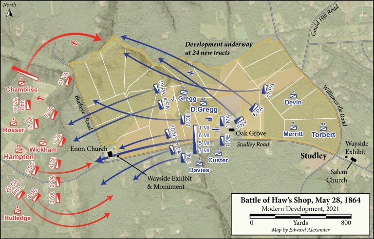
Haws-Shop-Development-Map.jpeg

In a February 2019 testimony before a congressional subcommittee, American Battlefield Trust president Jim Lighthizer warned that “in the next decade, most unprotected battlefield land will be either developed or destroyed.” Sadly, just over a year later his prediction has proven true on the largest, previously intact parcel of the Haw’s Shop battlefield. From rumblings on how the development played out, the Trust or any other preservation organization would have had a sizeable challenge in protecting the historic landscape. The likely outcome demonstrates the urgent need for preservation advocates to remain aware of potential harm to battlefields in their locale.

As Grant’s and Lee’s armies slowly slugged their way south from the Rapidan to the James, their cavalries also engaged one another with the same fierce consistency that is associated with the Overland campaign. During May alone, Phil Sheridan’s mounted corps battled Jeb Stuart and then Wade Hampton at Todd’s Tavern, Yellow Tavern, Meadow Bridge, Hanovertown, Haw’s Shop, Matadequin Creek, Hanover Court House, and Cold Harbor.

The fighting on May 28th west of Haw’s Shop marked the bloodiest cavalry battle since Brandy Station, almost a year prior. While Grant’s infantry prepared to surge across the Pamunkey River and Lee raced south from the North Anna to block the direct route to Richmond, Sheridan’s and Hampton’s troopers probed at one another throughout Hanover County. Both cavalry commanders sought to use the Atlee Station Road on May 28th and a brisk mid-morning skirmish between several battalions turned into a large-scale affair involving most of nine different brigades.

Beginning the engagement with only the Virginians under Williams Wickham and Thomas Rosser on hand, Hampton dismounted his Confederate cavalrymen and sprawled their battle line perpendicular to the Atlee Station Road west of Enon Church. Hampton anchored the flanks along Pollard and Mill Creeks and mulled taking the offensive. Meanwhile David Gregg summoned artillery to assist his Federal division and prepared to advance along the main road.

For four hours dismounted blue and gray troopers volleyed at one another from proper lines of battle. Occasional mounted charge threatened to tip the scales, but reinforcements evenly stabilized the lines on opposite sides of Enon Church. In an effort to outflank the tighter Union position along the road, Hampton swung Huger Rutledge’s South Carolinians and Georgians south of Wickham’s line and deployed John Chambliss’s Virginians above Pollard Creek. The arrival of Alfred Torbert’s division to reinforce Gregg negated these maneuvers.

At 4 p.m., while both sides jockeyed for position on the flanks, Custer’s Michigan brigade stormed directly west along the road, slamming into the Confederate line behind Enon Church. This determined movement forced Hampton to begin withdrawing his men, leaving the Federals in control of the battlefield. Nevertheless, the Confederate commander afterward claimed that he had fulfilled objective of gathering the intelligence necessary to inform Lee’s decision of where next to interrupt Grant’s maneuver–Totopotomoy Creek.

The one day of cavalry fighting produced over 700 casualties, slightly more of which were among Hampton’s Confederates. Wounded Union soldiers were taken to the home of John Haw, Oak Grove. Haw had operated a shop manufacturing farming and milling machinery, but the Seven Days battles convinced him to sell the equipment to the Tredegar Iron Works. The Haw family remained at Oak Grove until the 1950s while the area around the former shop developed into the small community of Studley, named after the nearby site where Patrick Henry was born in 1736.

Today Hanover County is a rapidly growing exurb boasting its business-friendly tax rates and standout test scores among its public schools. As the county expanded outward it overran many of its Civil War battlefields. One of the most notable examples can be seen at Beaver Dam Creek, where Lee first struck with his aggressive attacks that drove McClellan to the James River in 1862. This battlefield saw the first encroachment of modern development in the 1960s. Since then, the construction of I-295 straight through the site has prevented battlefield preservation and historical interpretation from extending beyond the tiniest of National Park Service walking paths.

The growth has continued northeastward, radiating outward from the city of Richmond and forcing county leadership to determine just how committed they are to preserving the landscape that has played such an important role in forming their cultural heritage. In late 2018, the American Battlefield Trust rallied donors to prevent the Hanover Board of Supervisors from constructing a large athletic facility where fighting took place both during Gaines’s Mill in 1862 and Cold Harbor in 1864. Preservationists unfortunately could not replicate that success at the core of the Haw’s Shop battlefield.

Public records show that after the latest resident to live in Oak Grove passed away in 2019, developers moved fast to purchase the land from the LLC that managed the entire tract stretching from Enon Church to Studley intersection where Haw’s Shop once stood. Immediately after finalizing its purchase of the property for over three million dollars in August 2020, the custom home builder split off twenty-four lots from the main house. These single-family homes will sit on 10-16 acres apiece and are expected to individually sell for over $600,000.

Haws-Shop-markers.jpeg

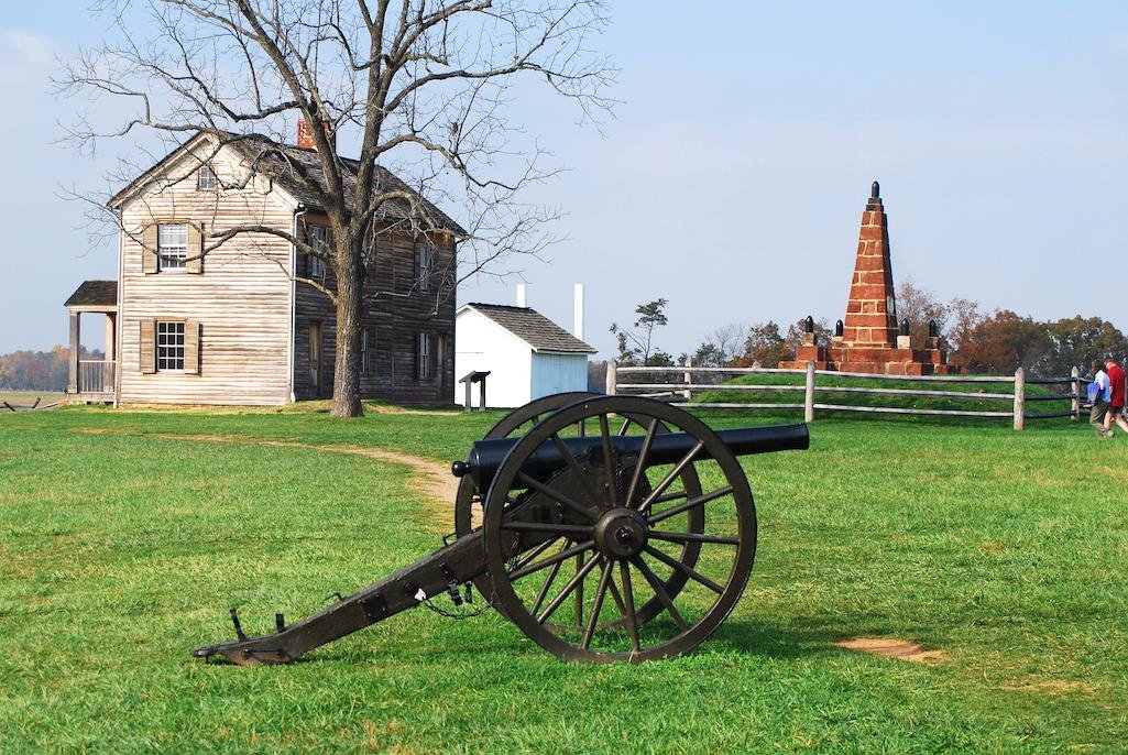
Those who wish to visit the Haw’s Shop battlefield can still find two Civil War Trails interpretive waysides by parking in the gravel lots at both Salem Church and Enon Church. The latter panel stands near a monument noting the twenty-seven Confederate soldiers buried in the churchyard. Nearby is the new location of a Freeman marker that barely survived a 2016 automobile collision when it formerly stood closer to the road.

May 15 Deadline to 28 Save Acres at Gettysburg and Bristoe Station

Screen Shot 2021-04-14 at 6.53.15 PM.png

FROM THE AMERICAN BATTLEFIELD TRUST:

Today, we have no time to spare. I need your help with saving two important Eastern Theater Civil War battlefields. For one of them, we only have 30 days. Our deadline is May 15th!

  We have the urgent opportunity to save 6 acres of hallowed ground at Gettysburg. At the same time, we have the opportunity to save 22 critical acres at Bristoe Station.

  Both of these battlefields face the imminent threat of residential and commercial development — unfortunately, pieces of each have already been lost.

  6 Acres at Gettysburg Near Culp’s Hill
This 6-acre parcel served as a key Union position near Culp’s Hill. Preserving this tract will not only add to our success along the Baltimore Pike but also fill in most of a key “hole in the donut” of preserved land between the Gettysburg Museum and Visitor Center complex with National Park Service land around Culp’s Hill.
If we are able to save this land in the next 30 days, we will have the chance to present new opportunities for interpretation and to helpfully provide easier access to this key part of the battlefield. Learn more about this tract »

22 Acres at Bristoe Station
This 22-acre parcel marked the position of Union troops led by General Joshua Owen, who acted as the main force to repel the Confederate attack.

  It’s also worth mentioning that these same 22 acres had seen action about a year earlier in the Battle of Kettle Run, a part of the Second Manassas Campaign, making this land twice hallowed.

  Encroachment is continually threatening this otherwise pristine battlefield, which means that it’s up to us to intervene. If we protect these acres now, we can preserve a crucial piece of the story of Bristoe Station. Learn more about this tract »

  Combined, these properties are worth more than $1.3 million.

  However, thanks to a generous contribution from the Gettysburg Foundation and anticipated funding from the federal American Battlefield Protection Program and other state and local sources, we only need to raise $103,500 to see this land saved forever. Meaning that any gift that you give today will be multiplied with an $12.87-to-$1 match!

  As more and more of our nation’s battlefield land faces the threat of destruction from development, I’m reminded of the absolute necessity of acting swiftly to ensure we don’t lose a single hallowed acre more.

 Please give today to ensure these 28 critical acres of hallowed ground are saved forever.

 ‘Til the battle is won,

David N. Duncan
President

Civil War Trust Announces 226 Acres Preserved at Four Battlefields

Screen Shot 2021-04-09 at 6.57.37 AM.png

{The Civil War Round Table of Eastern PA is proud to be a supporter of The Civil War Trust/American Battlefield Trust.}

While our work continues year-round, springtime is particularly bustling — especially at the 80 sites that will participate in the 25th Annual Park Day this upcoming weekend. And amidst the excitement, I bring good news: The Trust has preserved 226 acres across FOUR Civil War battlefields, two East and two West.

  All told, we are declaring victory at: 101 acres at Reams Station, and nearly three acres at Peebles Farm in Virginia, plus 120 acres at Jackson, Tennessee, and two acres at Champion Hill, Mississippi. With each property comes treasured history and landmark preservation moments...

  A special cause for celebration: the 120 acres at the Jackson Battlefield, or Salem Cemetery, mark our first piece of land saved at this western Tennessee site. Engrained in its soil are the memories of the December 19, 1862, battle, where two Union infantry regiments repulsed a Confederate mounted attack led by Brig. Gen. Nathan Bedford Forrest’s men. While first deemed a success, Union forces later learned that the encounter was a strategic distraction that allowed Gen. Forrest to destroy a section of railroad to the north. Seemingly minimal in scope, this battle exemplifies the clever, nimble tactics frequently seen in the Western Theater of war. Its significance was recognized, as the project received support from the American Battlefield Protection Program (ABPP) and was furthermore funded under a grant from the Tennessee Civil War Sites Preservation Fund, administered by the Tennessee Historical Commission.

  For our other Western Theater property, we look to west-central Mississippi, where the largest battle of Gen. Ulysses Grant’s Vicksburg Campaign took place on May 16, 1863. A Union victory, the Battle of Champion Hill — along with the next day’s battle at Big Black River — forced the Confederates into a doomed position inside the fortifications of Vicksburg. To save these two acres of hallowed ground, the Trust was aided by ABPP and the Mississippi Department of Archives and History.

  Both Eastern Theater properties are tied to the Petersburg Campaign, a series of complex efforts set forth by Grant and the Union army, that spanned some 10 months and hundreds of square miles.

  At Reams Station on August 25, 1864, Gen. A.P. Hill's infantry and Gen. Wade Hampton's cavalry attacked the Federals — soldiers from Gen. Winfield S. Hancock's II Corps who had ventured south of Petersburg to destroy the Confederates’ lifeline — the Weldon Railroad — amidst the siege of the Virginia city. The 101-acre property at Reams Station carries with it the stinging defeat felt by Hancock's men, but is now tempered in victory through the generosity of Trust members and a gift from the HTR Foundation, as well as matching grants from ABPP and the Virginia Battlefield Preservation Fund (VBPF).

  The other Virginia tract — a small property measuring just less than three acres — is twice hallowed, having seen action on September 30 – October 2, 1864, during the Battle of Peebles’ Farm, and during The Breakthrough at Petersburg on April 2, 1865. This land ultimately witnessed the end of the nine-month-long Siege of Petersburg, which led to the collapse of Lee’s defense of the city. The Trust acquired this storied site through the support of ABPP.

  In all, this is a wonderful triumph not only for battlefield preservation, but for YOU, who brought this crucial effort to the finish line! I hope this news was a breath of fresh spring air that inspires you to get outside, visit a battlefield, and fully immerse yourself in the history that drives us ever-forward in our profound mission.

 With gratitude,
David N. Duncan
President

Six Acres Preserved at Bentonville

Screen Shot 2021-03-19 at 1.05.12 PM.png

Each day, the American Battlefield Trust fights to ensure that America’s historic, hallowed ground remains a fixture for this and future generations. Well, that fight — one you constantly carry forward with your abundant support — has resulted in yet another preservation victory: Six acres at the Bentonville Battlefield in Johnston County, N.C.  

  The Battle of Bentonville began on this day in 1865 and lasted three days, going down in history as the largest battle ever fought in the Tarheel State. Furthermore, it functioned as a catalyst that set off the last series of standoffs between Union Gen. William Tecumseh Sherman and Confederate Gen. Joseph E. Johnston’s Army of Tennessee, as Federal forces closed in around the Confederate army.

  The six acres you’ve helped us secure were integral to the first day at Bentonville and set the stage for the following two days of fierce fighting at this central North Carolina site. Consisting of two separate parcels of land, the preserved properties witnessed action brought forth by Confederate forces as they launched assaults and maneuvers against Union troops. But regardless of what was thrown against them, the men in blue held their ground and, as the sun set on that first day, fighting resulted in a tactical draw. Ultimately, the tide would turn in the Union’s favor at Bentonville, with war in the Western Theater drawing to a close.

  Recognized as a vital part of the battle’s story, the preservation of this acreage drew the support of not only the Trust’s crucial members — like yourself, but also the American Battlefield Protection Program. With an army this size to drive our success, the properties have not only been saved, but already transferred to the State of North Carolina for incorporation into Bentonville Battlefield.

  And while the Trust has successfully saved more than 1,860 acres at this site, our work is still not done. Currently, we are working to preserve an additional seven acres at Bentonville — land that will bring us ever-closer to finishing the preservation of the First Day’s Battle, and a task that will require the continued support of our unwavering army of preservation champions.

 All my thanks,

 David N. Duncan, President ABT

CWRT of Eastern PA Inducted into the American Battlefield Trust's "20 Year Club"

Screen Shot 2021-03-08 at 11.45.52 AM.png

The Civil War Round Table of Eastern PA has been recognized by the American Battlefield Trust as a member of it’s “20 Year Club” due to our "singular and extraordinary dedication to saving America's History". This is one of the Trust's newest recognition societies. Their will be a printed, bound-book the "President's Roll Call of Honor" in which our name will appear. Also there will be a digital "Roll Call of Honor with our name on it.

ABT notes that the 20-Year Club is a core group of dedicated battlefield preservationists who have generously supported this great cause for 20 years or more. Their selfless financial support has directly led to the preservation of more than 53,000 acres of hallowed American battlefield land. They have helped make us the most successful historic land preservation organization of its kind in American history. That is an amazing legacy.

Thank you to our 20-Year Club members for all they have done – and continue to do – for this great cause.

Adams County (PA) Historical Society Capital Campaign for New Building

Saving Our History

Screen Shot 2021-03-05 at 2.05.20 PM.png

It may surprise you to learn that literally millions of irreplaceable Gettysburg & Adams County artifacts are at risk of being lost forever. Here in Gettysburg, the Adams County Historical Society needs your help to protect these precious materials before it is too late. We're excited to announce plans to build a new Exhibit Gallery, Archives, and Education Center in Gettysburg to preserve these treasures and share the untold story of one of America's most famous communities. 

Your gift will help make this vision a reality.

Will you join us? Scroll down to learn more!

Click HERE to donate today!

FOR A PDF COPY OF THE CAMPAIGN BROCHURE - CLICK HERE

Help Preserve 95 Acres at Three 1864 Battlefields

Screen Shot 2021-03-05 at 1.56.53 PM.png

Three 1864 Battlefields in need of your support: 

  • Battle of Mansfield, Louisiana
    The casualties were staggering — in General Alfred Mouton’s Confederate brigade, nearly every regimental commander was killed. One Union Thirteenth Corps division lost 43 percent of its men, killed, wounded and captured. An Ohio Infantryman later said of the battle that the bullets rained down “like a hailstorm,” and Joseph Blessington commented that “the road was red with their blood,” when describing the Union retreat. Read more about this battlefield »

  • Battle of The Wilderness, Virginia
    At the very beginning of Grant’s Overland Campaign, the Wilderness marked the first major battle between the newly appointed Union commander and his Confederate counterpart, General Robert E. Lee. From this parcel, the Confederates launched part of the counterattack that stymied the Union advance along the Orange Turnpike. Read more about this battlefield »

  • First Battle of Deep Bottom, Virginia
    Playing a role in the Petersburg Campaign in the summer of 1864, this 39-acre parcel outside of Richmond, Virginia saw action in both the First Battle of Deep Bottom in July of 1864 and in the Battle of Glendale two years before, meaning this land is twice hallowed. Preserving this land will also simultaneously protect the history of Gravel Hill, a unique and historically significant community in its own right. Read more about this battlefield »

We have already secured more than 88% of the funds needed to pay for more than $1.2 million of transaction value, but we still have $144,671 to raise. Meaning that any gift that you give today will be multiplied with an $8.90-to-$1 match

Each of these battles is a piece in the puzzle of the larger strategies that characterized the final year of the war. But if we don’t act swiftly, these 95 acres of hallowed ground could be lost forever! 

As there is simply no substitute for walking on the very ground where important history happened, I ask you to make your most generous gift today to ensure that future generations will always be able to explore and learn from our unique American battlefields. 

'Til the battle is won,
David N. Duncan
President