Preservation Setback at the Haw’s Shop Battlefield
from Emerging Civil War
Posted on May 28, 2021 by Edward S. Alexander
In a February 2019 testimony before a congressional subcommittee, American Battlefield Trust president Jim Lighthizer warned that “in the next decade, most unprotected battlefield land will be either developed or destroyed.” Sadly, just over a year later his prediction has proven true on the largest, previously intact parcel of the Haw’s Shop battlefield. From rumblings on how the development played out, the Trust or any other preservation organization would have had a sizeable challenge in protecting the historic landscape. The likely outcome demonstrates the urgent need for preservation advocates to remain aware of potential harm to battlefields in their locale.
As Grant’s and Lee’s armies slowly slugged their way south from the Rapidan to the James, their cavalries also engaged one another with the same fierce consistency that is associated with the Overland campaign. During May alone, Phil Sheridan’s mounted corps battled Jeb Stuart and then Wade Hampton at Todd’s Tavern, Yellow Tavern, Meadow Bridge, Hanovertown, Haw’s Shop, Matadequin Creek, Hanover Court House, and Cold Harbor.
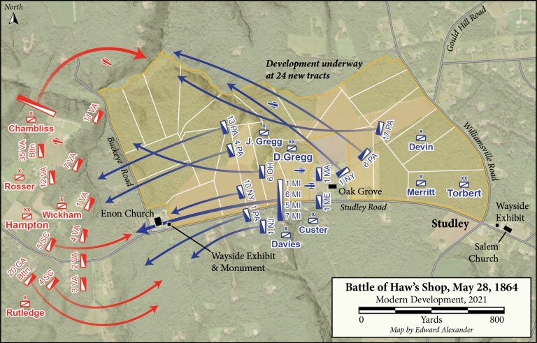
The fighting on May 28th west of Haw’s Shop marked the bloodiest cavalry battle since Brandy Station, almost a year prior. While Grant’s infantry prepared to surge across the Pamunkey River and Lee raced south from the North Anna to block the direct route to Richmond, Sheridan’s and Hampton’s troopers probed at one another throughout Hanover County. Both cavalry commanders sought to use the Atlee Station Road on May 28th and a brisk mid-morning skirmish between several battalions turned into a large-scale affair involving most of nine different brigades.
Beginning the engagement with only the Virginians under Williams Wickham and Thomas Rosser on hand, Hampton dismounted his Confederate cavalrymen and sprawled their battle line perpendicular to the Atlee Station Road west of Enon Church. Hampton anchored the flanks along Pollard and Mill Creeks and mulled taking the offensive. Meanwhile David Gregg summoned artillery to assist his Federal division and prepared to advance along the main road.
For four hours dismounted blue and gray troopers volleyed at one another from proper lines of battle. Occasional mounted charge threatened to tip the scales, but reinforcements evenly stabilized the lines on opposite sides of Enon Church. In an effort to outflank the tighter Union position along the road, Hampton swung Huger Rutledge’s South Carolinians and Georgians south of Wickham’s line and deployed John Chambliss’s Virginians above Pollard Creek. The arrival of Alfred Torbert’s division to reinforce Gregg negated these maneuvers.
At 4 p.m., while both sides jockeyed for position on the flanks, Custer’s Michigan brigade stormed directly west along the road, slamming into the Confederate line behind Enon Church. This determined movement forced Hampton to begin withdrawing his men, leaving the Federals in control of the battlefield. Nevertheless, the Confederate commander afterward claimed that he had fulfilled objective of gathering the intelligence necessary to inform Lee’s decision of where next to interrupt Grant’s maneuver–Totopotomoy Creek.
The one day of cavalry fighting produced over 700 casualties, slightly more of which were among Hampton’s Confederates. Wounded Union soldiers were taken to the home of John Haw, Oak Grove. Haw had operated a shop manufacturing farming and milling machinery, but the Seven Days battles convinced him to sell the equipment to the Tredegar Iron Works. The Haw family remained at Oak Grove until the 1950s while the area around the former shop developed into the small community of Studley, named after the nearby site where Patrick Henry was born in 1736.
Today Hanover County is a rapidly growing exurb boasting its business-friendly tax rates and standout test scores among its public schools. As the county expanded outward it overran many of its Civil War battlefields. One of the most notable examples can be seen at Beaver Dam Creek, where Lee first struck with his aggressive attacks that drove McClellan to the James River in 1862. This battlefield saw the first encroachment of modern development in the 1960s. Since then, the construction of I-295 straight through the site has prevented battlefield preservation and historical interpretation from extending beyond the tiniest of National Park Service walking paths.
The growth has continued northeastward, radiating outward from the city of Richmond and forcing county leadership to determine just how committed they are to preserving the landscape that has played such an important role in forming their cultural heritage. In late 2018, the American Battlefield Trust rallied donors to prevent the Hanover Board of Supervisors from constructing a large athletic facility where fighting took place both during Gaines’s Mill in 1862 and Cold Harbor in 1864. Preservationists unfortunately could not replicate that success at the core of the Haw’s Shop battlefield.
Public records show that after the latest resident to live in Oak Grove passed away in 2019, developers moved fast to purchase the land from the LLC that managed the entire tract stretching from Enon Church to Studley intersection where Haw’s Shop once stood. Immediately after finalizing its purchase of the property for over three million dollars in August 2020, the custom home builder split off twenty-four lots from the main house. These single-family homes will sit on 10-16 acres apiece and are expected to individually sell for over $600,000.
Those who wish to visit the Haw’s Shop battlefield can still find two Civil War Trails interpretive waysides by parking in the gravel lots at both Salem Church and Enon Church. The latter panel stands near a monument noting the twenty-seven Confederate soldiers buried in the churchyard. Nearby is the new location of a Freeman marker that barely survived a 2016 automobile collision when it formerly stood closer to the road.

