Marking a Milestone: 2,000+ Acres Saved at Bentonville

FROM - The American Battlefield trust:
I’m especially thrilled when I can share with you the crossing of a preservation milestone and our most
recent victory of 144 acres saved at Bentonville, North Carolina, does just that. With the now completed transfer of that land to the State and its incorporation into the Bentonville Battlefield State Historic Site, the Trust, with the help of our members and partners, has saved more than 2,000 acres of battlefield land at Bentonville, the most acres saved at any battlefield outside of Virginia and the Eastern Theater of the Civil War. Preserving this land helps us share with future generations a more complete history of the conflict, and we thank you!

Last Stand

In the waning weeks of the war, the March 19-21, 1865, Battle of Bentonville, the largest fought in North Carolina, was part of the last series of standoffs between Union Maj. Gen. William Tecumseh Sherman and Confederate Gen. Joseph E. Johnston, as Federal forces pushed toward Goldsboro and the completion of the Carolinas Campaign. At this central North Carolina site, the Confederates took the first step in their final stand.

At 10:15 on the morning of March 20, 1865, Johnston received word from Gen. Evander Law of the approach of the Federal Right Wing and ordered Gen. Robert F. Hoke to swing his division back to a position, parallel to and north of the Goldsboro Road.

The Federal Right Wing had been in a running fight with Confederate cavalry under the command of Gen. Law for more than eight miles. The Federal XV Corps, under command of Maj. Gen. John Logan was first to arrive with Bvt. Maj. Gen. Charles Woods’ division in advance. Gen. Woods deployed the Second Brigade under Colonel Robert Catterson with skirmishers of the 100th Indiana advancing to clear the intersection held by the southerners of Brig. Gen. Johnson Hagood’s Brigade.

As this fight was in progress Generals Oliver Otis Howard, Logan and Woods had ridden up very close to the skirmish line when elements of Lt. Gen. Wade Hampton’s Cavalry came out of the woods to the left and behind the Federal skirmish line nearly capturing the trio and some of their staff. A change of front and several well-placed volleys from the reserves of the 100th drove the southern cavalry off the field, eventually clearing the intersection of any resistance.

The sudden tumult frightened the 100th Indiana’s pack mules, who bolted for the rear, “and the air for a while seemed to be as full of frying pans, coffee pots, tin plates and cups as bullets,” wrote one onlooker from the 97th Indiana.

Once this area was cleared of the opposing forces, the land here was occupied by the Third Division under command of Bvt. Maj. Gen. John Smith and the Fourth Division of Bvt. Maj. Gen. John Corse.

Becoming Whole

These newly preserved acres are located on that portion of the battlefield where Day Two fighting took place. Surrounded by the Bentonville Battlefield State Historic Site, the preservation of this tract will enable the connection of existing and planned for trails and interpretation, in addition to the existing four and one-half miles of trails.

“At Bentonville, we are working towards a critical mass that allows for many of these properties to interlock and become whole,” says Kathy Robertson, the Trust’s Director of Project Management. “This, in turn, benefits the trails that visitors seek out to explore and understand the battle’s history.”

The threat of development, especially industrial-scale solar farm development, loomed large over this site and it still does over others. Thanks to the help of funding from the American Battlefield Protection Program and the North Carolina State Capital Infrastructure Fund and, of course, the help of our members and donors, we can claim this victory that not only helps connect the Bentonville battlefield and moves closer to making it whole but marks a milestone in battlefield acreage saved outside of the Eastern Theater of war.

All battlefield land is important. We’re grateful for the help to save this hallowed ground and announce this victory, with a pledge to continue the fight for more. Thank you and congratulations!

Sincerely,

David N. Duncan, President

American Battlefield Trust

P.S. Can't make it to this battlefield? Take a 360° virtual tour of Bentonville Battlefield State Historic Site on our website!

Protect Chancellorsville Battlefield

Some battles are named after geographic features such as rivers or mountains, others for nearby towns or cities. The May 1863 Battle of Chancellorsville took its name from an intersection at the heart of where fighting occurred, near the stately Chancellor House. Only ruins now remain of the dwelling, but it’s still a place of pilgrimage for students of history.

Today, this iconic part of the Chancellorsville battlefield is a target for developers seeking to build a gas station, convenience store and professional complex on westbound Route 3, a scant 1,500 feet from the historic Chancellorsville intersection.


An artist's rendering showing combat on the 11-acre property (shaded in grey) contemplated for a gas station and other commercial development. Fighting raged across this tract on May 3, 1863, as Confederates assaulted the federal lines protecting the Chancellor House intersection. (Peter Giraudeau/Hill Studio)

Both contiguous to and across Route 3 from land protected as part of Fredericksburg and Spotsylvania National Military Park, this is a site that even the most casual evaluation would recognize as deeply historic. It is core battlefield upon which Union troops were entrenched throughout the battle and where fierce fighting took place on the morning of May 3 (see our Battle Map here), when a Confederate assault dislodged Union troops from their concentrated position around the Chancellor House. This land’s listing on the Virginia Landmarks Register, position within a county-designated historic district, and location immediately adjacent to the Congressionally authorized boundary of the National Park all bear witness to the significance of the site.

This land has a history that demands more than pay-at-the-pump accessibility.

For two decades, the Trust and its allies have worked to protect critical portions of the Chancellorsville Battlefield. Longtime members will remember our triumphant negotiation with developers to craft a win-win solution that saw us preserve the First Day at Chancellorsville site – now home to beloved walking trails and the Spotsylvania County Museum. For years, this nearly 2 miles of conserved road frontage along Route 3 has held in check development pressure spreading west from Fredericksburg.

Bad enough in its own right, we fear that the proposed gas station complex could be the spark that jumps this figurative firebreak and opens the eastern part of the battlefield to development. That would decrease the impact of the work we and our allies at the Central Virginia Battlefields Trust have accomplished at Chancellorsville and make future acquisition efforts even more of an uphill battle. We need YOU to speak out to protect Chancellorsville.


1. Sign a Letter of Opposition

Please visit our website to learn more about this proposal and sign a letter of opposition that we can provide to elected officials – and share this opportunity with your friends. We need to send a message that while modern infrastructure is necessary, we need not sacrifice our history in the process.


LOCAL RESIDENTS: Sign this letter to governement officials

CONCERNED PRESERVATIONISTS: Sign this letter


2. Attend a Public Meeting on August 10 at 6 pm

Local voices are especially important, as constituent opinion carries tremendous weight with government decision makers! In addition to having a specific letter just for area residents, we are calling on those who live nearby to attend a public meeting on August 10 at 6 pm at the Chancellor Ruritan Club located at 5994 Plank Road, Fredericksburg, Virginia 22407. If you are able, please attend and be counted among those who will take a stand for Chancellorsville.

With great appreciation,

Jim Campi, Chief Policy & Communications Officer

American Battlefield Trust

P.S. Thanks to your years of consistent support for Chancellorsville, hundreds of acres of hallowed ground are saved there. Please rally once again for this battlefield by making your voice heard!

Preserve puzzle pieces at Champion Hill & Chickasaw Bayou

Battlefield preservation is like putting together a thousand-piece jigsaw puzzle. It takes patience and time... Piece by piece, parcel by parcel, until it slowly comes together. 

And if a piece is lost, it leaves a hole that jeopardizes the entire picture.

When there are unprotected tracts in the middle of a battlefield — it can take years or even decades for those tracts to become available.


And then when they do, we must hope and pray that the seller is willing to listen to our offer... and that they won’t be seduced by the well-financed developers and real estate brokers working on behalf of data warehouses and solar farm companies who are looking to buy up everything in sight.


We are facing unprecedented, generational threats to our mission to preserve hallowed ground. And quite frankly, we need heroes. 

Today, we have an opportunity to save nearly 32 acres of battlefield land at Chickasaw Bayou and Champion Hill in Mississippi. 

These tracts are the very definition of puzzle pieces. The project we have before us includes purchasing twelve individual parcels — each a small piece of the puzzle — that dot these battlefields and help fill in the gaps of the Vicksburg Campaign’s story.


Paul, stringing together a dozen parcels and a half dozen willing sellers at Champion Hill and Chickasaw Bayou is no easy feat.


The total value for all these parcels is more than $2.1 million.


That’s far more than we could normally afford, but we’ve applied for federal and state grants — some have already been awarded, and some are still pending — that could help get us over the finish line.


If we are able to secure these grants, the Trust would still need to come up with an additional $327,825 to close the deal. That means that every dollar you can contribute is multiplied by $6.50!


In an age where our history is at risk, I hope I can count on you to make a generous gift to ensure this land in Mississippi is saved forever.


If we don’t do this now, we might never have the opportunity again. 

‘Til the battle is won,

David N. Duncan, President

American Battlefield Trust

P.S. These battlefields represent some of the most significant battles in the Civil War. As you may know, the Vicksburg Campaign is often called one of the turning points, if not the turning point, of the Civil War.

Please make your gift, knowing this is our once-in-a-generation opportunity to buy, and protect forever, almost 32 acres of the remaining pieces of the Vicksburg Campaign. 

Taking Back Tennessee One Parcel at a Time: 3 Acres Saved!

From the American Battlefield Trust

At our recent Annual Conference, held May 18-21 in Franklin, Tenn., I heard time and time again from our members and attendees what a powerful testament to preservation the Franklin Battlefield encapsulates. Where once a Pizza Hut stood, now there are cannons and battlefield, lined with historically accurate rail fence that perfectly mirrors 19th-century photos of the land where the Battle of Franklin raged November 30, 1864. What better way to teach the past could we possibly create? 

Folks, there is none. The power of place is incomparable. And every acre counts, which is why I’m excited to share two more victories in Tennessee, saving over three acres that reclaim battlefield land at the Battles of Franklin and Davis Bridge.

‘Lost’ under concrete

In November of 1864, Confederate General John Bell Hood and his Army of Tennessee sought to bring a decisive blow to Union General John Schofield. After a month of sparring, the Federals had dug in at Franklin, forcing Hood to make a frontal assault over two miles of open ground against a numerically equal foe entrenched behind three lines of breastworks. Confederate forces were immediately assailed by cannon and small-arms fire but managed to splinter the Union center briefly. After nearly three hours of intense fighting, the Army of Tennessee pulled back, decimated.  

For decades, the battlefield at Franklin was considered “lost” under the concrete and asphalt of development, but recent and gallant preservation activity has reclaimed the site one small parcel at a time and restored a growing battlefield park. While we and our partners have just announced an effort to save an important tract near the Carter House, we are pleased to report that two more acres along the Lewisburg Pike, where Confederate General Thomas Scott’s brigade of Louisiana, Alabama and Tennessee troops made a final push towards the left flank of the Union line, are now saved forever.    

Described by Battle of Franklin Trust CEO Eric Jacobson as “one of the last available, most important unpreserved properties in Franklin,” the site was a high priority for acquisition. When it went up for auction, representatives of Battle of Franklin Trust, the Friends of Franklin Parks, Franklin’s Charge, and Save the Franklin Battlefield — buoyed by a $25,000 grant from the American Battlefield Trust — mobilized and took action. Friends of Franklin Parks was victorious at auction and now with the monies all raised, the Trust can now proclaim more than 180 total acres saved at Franklin.

Saving the Epicenter of the Battlefield

On the night of October 4, 1862, Union Maj. Gen. Edward O.C. Ord camped near Pocahontas, Tennessee. In the morning, a division of Illinois and Indiana regiments in the area under Maj. Gen. Stephen A. Hurlbut discovered Confederates in their front, two miles south of town. Ord took command of the combined Union forces and pushed Confederate Maj. Gen. Earl Van Dorn’s advance line, General Sterling Price’s Army of the West, back about five miles to the Hatchie River and across Davis Bridge. Price and Van Dorn put up a stubborn defense of the bridge to protect their line of retreat. During the action, Ord was wounded and Hurlbut assumed command. While Price’s men were hotly engaged with Hurlbut’s force, Van Dorn’s scouts found another crossing of the Hatchie further south at Crum’s Mill and Van Dorn led his army back to Mississippi. Ord had forced a Confederate retreat, but they escaped capture or destruction. Now, one acre of land, the epicenter of a key portion of the Davis Bridge battlefield, has been saved and transferred to the Shiloh National Military Park.

Bringing back Tennessee battlefield one parcel, one acre at a time, is arduous work, but work that’s worthy of our efforts. With your commitment and ours, we can and will continue to claim victories such as these that help us tell the stories of these great battles in a way that only the power of place can do. Thank you!

Sincerely, David N. Duncan

President, American Battlefield Trust

Zoom Update on Battlefield Threats ~ June 21st at 1pm


This summer, a number of battlefields are in the crosshairs of developers bent on burying them under distribution warehouses and data centers. At places like the Wilderness and Manassas, the threat isn’t theoretical or conceptual – it is urgent and very real.  

In fact, the Trust has taken the exceptional step of filing as lead plaintiff in a lawsuit to overturn a massive rezoning that could place millions of square feet of such industrial development at the gateway to the Wilderness Battlefield – centered on the same intersection that, 10 years ago, we successfully convinced Walmart was not the optimal location for its Orange County supercenter.  

Please join me and members of our Policy team on Wednesday, June 21 at 1pm ET, for a very special briefing focused on the tangible and time-sensitive steps the Trust is forced to take in the face of these unprecedented and dire threats.

Sign up HERE to participate via Zoom! Once signed up, we will use the email address provided to send you instructions and a link and passcode to join. I hope you can join us. If you cannot tune in live, a recording will be available afterwards. 

We will have a Q&A session at the end of the call. If you would like to submit a question in advance, please email
RSVP@battlefields.org


Sincerely, David N. Duncan

President, American Battlefield Trust

Bring Home Jonathan Taylor's Sword

Jonathan Taylor was born in Carbon County, on the 21st of April, 1842. He and his family moved to Bethlehem in 1858. When war came on April 12, 1861, he was still a pupil.

Jonathan enlisted in Co. A, 1st PA Volunteers for 3 months as a private. The unit was mustered in at Harrisburg on April 20th, the day before his 19th birthday & only 8 days after the firing on Charleston’s Fort Sumter. Mustered out on July 27th, Jonathan Taylor came home. 

By the summer of 1862 when President Abraham Lincoln called for more men, young Taylor was among the first to respond. His companions were many of the most gallant young men of Bethlehem. Civil War armies were very democratic and although young, he was brave, patriotic, earnest, and in every respect competent, and was elected to Captain of Company C, 129th Regiment PA Volunteers. As an officer he always enjoyed, not only the respect of his men, but also the confidence of his superiors. He was given a sword, a symbol of authority, to be carried in battle. It’s scabbard was inscribed, “Presented to Jon.thn K. Taylor by his Friends Bethlehem Pa” The regiment was mustered into the Union Army at Harrisburg on August 15.

On December 13, 1862, Taylor and his regiment were with the Army of the Potomac before Mayre’s Heights and participated in the carnage of the Battle of Fredericksburg. Federal forces hurled flesh and bone against fellow Americans behind a stone wall with a sunken road and when the bloody day was over and all assaults by the army had ultimately failed, the 129th had suffered 142 men killed, wounded or missing. One of those was young Taylor who we believe fell carrying his sword. Severely wounded, he suffered and fought one last battle, finally succumbing to his injuries 105 days later on March 28, 1863.

The train bearing his remains arrived in Bethlehem and was greeted by a city in mourning. Businesses were closed, children and adults lined the path to his home. His funeral took place from the residence of his parents on Wednesday, April 1st. All were saddened at the loss of this truly brave and patriotic young officer. As Captain Taylor, was a frequent visitor of the Moravian Church and agreeably to the desire of his bereaved parents, the Moravian cemetery was made his final resting place.   

The Grand Army of the Republic was a Veterans organization formed in 1866. Posts were formed throughout the country by veterans who lived in that community. Many Posts were named for officers of high rank. Bethlehem’s Post 182 became the Jonathan K. Taylor Post. He was the only officer from Bethlehem to die from wounds in battle and it was altogether fitting and proper to honor his service, leadership and ultimate sacrifice. A monument for Post 182, is located in the Rose Garden across the street from Nitschmann Middle School.

A partnership of the GAR Civil War Museum of Philadelphia, Historic Bethlehem Museums & Sites, the Bethlehem Area School District & The Civil War Round Table of Eastern PA, Inc. has been formed to bring Jonathan’s sword home. Ownership will pass to the GAR Museum. We need $9000 to acquire to sword where it will be a focal part of a larger display at Bethlehem’s Nitschmann Middle School. Students from all over the district will learn of the local connection to the Civil War & have the opportunity for research projects that go deeper than normal classroom study.

Checks payable to: GAR Museum // In Memo line: “Taylor Sword Fund Donation”

Send to: Taylor Sword Fund c/o GAR Museum
8110 Frankford Ave  Philadelphia, PA 19136

Years in the Making: 44 Acres Transferred to the National Park Service

The passage of time never ceases to amaze me. For all that I talk about us being in “the forever business” and spend my days thinking about events that happened 160 or 240-something years ago, it can be easy to lose sight of the rate at which the wheels of preservation turn.

Today I want to tell you about the ultimate fate, the full-circle moment for a 29-acre property at White Oak Road that we bought in 2001. I was only in my third year with the Trust, and the organization looked much different than it does now: smaller staff, fewer members and a much smaller preservation footprint in terms of acres, sites and states.

When we first bought that land, we couldn’t have transferred it to the National Park Service. But with patience and an act of Congress expanding the authorized boundary beyond the siege to include the broader campaign, it is now – 22 years later! – a part of Petersburg National Battlefield. All told, in the last few months, we’ve seen four properties totaling 44 acres integrated into three different national parks.  

Strategic Advance – White Oak Road

On March 31, 1865, in combination with Maj. Gen. Philip Sheridan’s cavalry thrust via Dinwiddie Court House, Maj. Gen. Gouverneur Warren directed his V Corps against Confederate entrenchments along White Oak Road, hoping to cut General Robert E. Lee’s communications with his men at Five Forks.

The 29 acres now owned by the National Park Service are crucial to understanding and interpreting the initial phases of the battle where severe fighting occurred and three undersized Confederate brigades managed to turn the Federal left flank and drive two Union divisions from the field in what historian A. Wilson Green calls “a remarkable tactical achievement.” When the Union’s counterattack succeeded, Confederate forces retreated across this very land.

In their push forward, the Union troops had gained possession of White Oak Road west of the Confederate entrenchments and successfully cut off Lee’s ability to later support Maj. Gen. George Pickett and Maj. Gen. W.H. Fitzhugh Lee at Five Forks, setting the stage for a Union victory there on April 1.  

Securing Shiloh

Two victories in Shiloh, Tenn., total nearly 8 acres transferred to the National Park service in October. They include a 1.88-acre tract that played a role on the first day of the Battle of Shiloh, when Mississippi Regiments from Brig. Gen. James Chalmers’ brigade advanced over this tract to engage elements of Col. David Stuart’s brigade of Brig. Gen. William T. Sherman’s division. The federals managed to hold on against the Confederate onslaught for about 90 minutes before they withdrew.

The larger, 5.81-acre property is in the rear area where the initial Union camp was established at Pittsburg Landing prior to the battle. On the night of April 6, 1862, exhausted Union soldiers took refuge here behind Union Brig. Gen. Ulysses S. Grant’s Last Line, even as they general pledged he would “Lick ’em tomorrow though.”  

A Stones Throw

Also now part of a national park is a little over 6 acres associated with fighting on the final day of the Battle of Stones River January 2, 1863. As a Confederate attack pushed toward the ford, they came within range of 57 Union cannon massed on the west side of the Stones River. General George Crittenden watched as his guns went to work, later reporting: “[Brig. Gen. Horatio] Van Cleve’s Division of my command was retiring down the opposite slope, before overwhelming numbers of the enemy, when the guns...opened upon the swarming enemy. The very forest seemed to fall...and not a Confederate reached the river.”

Stones River National Battlefield can be viewed as an island surrounded by sprawl, making each acquisition there, and each addition to the park, precious. We’re especially pleased because the Trust protected an adjacent 42-acre tract that will also help ensure the preservation of this section of the battlefield.

I am so grateful for the supporters who make this work possible. So many of you are with us for the “long haul” -- even if it takes us two decades for a preservation story to reach its conclusion! And we do have plenty more work ahead of us: right now, we’re seeking to save 343 acres spread across the crucial battlefields at Chickamauga, Brice’s Cross Roads, Wyse Fork, Bentonville, and Shiloh. Learn more about the exceptional matching funds that will help us tell the full story of the Civil War on the land where it unfolded.

Til the Battle, etc. 

David N. Duncan, President

American Battlefield Trust

Stand Up Against Mega-Development at Wilderness Battlefield

It’s been a few years since I’ve had to use this phrase – but I need you to help save the Wilderness! This iconic battlefield, known for its dense foliage, scenic roadways and rural character, is again threatened by development. But this time, the sheer amount of industrial, commercial and residential development is staggering: 2,600 acres of rolling woodland overrun with 5 million square feet of industrial space (for data centers and distribution centers), up to 5,000 residential units, and 200,000 square feet of mixed-use commercial development. This is a scale of development truly unprecedented for this rural county.   

Worse still, it’s all located immediately adjacent to land we’ve fought for before.

Longtime Trust members will probably have a bit of a flashback when they read “Stop the Wilderness Walmart.” They’ll remember the years-long advocacy campaign that emerged when Walmart wanted to build a supercenter at the gateway of the Wilderness Battlefield, on property used as a Union Army command post and artillery park, and best remembered for the famous panorama drawing by combat artist Edwin Forbes. The site is also adjacent to the intersection where the Civil War changed course – where, after a three-day bloodletting led to stalemate in the Wilderness, Lt. Gen. Ulysses Grant turned his army south, advancing for another 10 months until the fall of the Confederate capital at Richmond.

Well, in 2009 and 2010, preservationists kept advancing the colors too. Along with our partners in the Wilderness Battlefield Coalition, we ultimately had to go to court – convincing Walmart to build elsewhere in the county, outside the gateway area.

The Walmart controversy also resulted in a broader conversation about responsible growth in the battlefield gateway vicinity, which stands at a busy intersection near the boundary between relatively rural Orange County and more suburban Spotsylvania County. In response, the Wilderness Battlefield Coalition collaborated with community groups, local officials, residents and landscape architects on the 2012 Wilderness Gateway Study that provided a blueprint for balancing development and open space in the region. The principles it espoused were later adopted by Orange County in its 2015 Germanna-Wilderness Area Plan.

Fast forward eight years: The Wilderness Crossing mega-development plan going before the planning commission this month ignores the hard-won, consensus-based recommendations of the Wilderness Gateway Study and the Germanna-Wilderness Area Plan in favor of development on a scale never before seen in Orange County.  Already congested roadways will be utterly overwhelmed, resident services will be stretched to the breaking point and beyond.  

Once again, we are calling upon preservation advocates and local residents to take a stand for the Wilderness Battlefield. Please attend the Planning Commission hearing on March 23 and urge the county to adhere to its own guidance for development in this sensitive area. If you live further afield or cannot attend in person, you can sign a letter urging county officials to reconsider.

Learn more about the Planning Commission Hearing

Orange County Residents: Sign the Letter

Concerned Preservationists: Sign the Letter

A decade ago, we took a stand for the Wilderness in one of the most hard-fought grassroots efforts in Trust history. Now is the time to hold the line, to insist that Orange County follows through on its own recommendations in order to protect this priceless piece of history. 

With great appreciation,

Jim Campi, Chief Policy and Communications Officer

American Battlefield Trust

A Trust Triumph: 47 Acres Saved in the Old Dominion!

As we stroll into the month of March, we continue to set our sights on the places where soldiers marched, fought and sacrificed — leaving behind powerful stories with every footstep they planted in the soil. Marching with a mission, we at the American Battlefield Trust always delight in sharing victorious news with you. So, I am enthused to announce that the American Battlefield Trust has protected 47 acres across Virginia’s Cedar Creek and Cedar Mountain battlefields!

  But what makes this news more meaningful is that the roughly two and a half acres at Cedar Creek have been transferred to the National Park Service for incorporation into Cedar Creek and Belle Grove National Historical Park. What this does is help to create a fuller experience at the site of one of the boldest military moves of the Civil War!


It Takes an Army

  The effort at Cedar Creek wouldn’t have been possible without the help of the National Park Service, the Shenandoah Valley Battlefields Foundation (SVBF) and your continued support. SVBF helped maintain the land prior to transfer and in the future, the Trust will work towards the removal of post-war structures post-transfer.


Development and Sites of Historical Significance Don’t Mix!

  With such a crowd supporting the Cedar Creek tract’s preservation, it is important to remember why. To start, Cedar Creek is one of the most threatened battlefields in America due to an international mining company already owning more than 500 acres of battlefield land. Additionally, this land felt the determined actions of Union and Confederate troops on October 19, 1864.

  After Lt. Gen. Jubal Early launched his surprise attack on Maj. Gen. Philip Sheridan’s Army of the Shenandoah, Union troops under Hayes and Kitching retreated across this land sometime after 6 a.m. But they were pursued by Confederate Maj. Gen. Stephen D. Ramseur's division. While attempts were made to hold off Ramseur’s attack, the Union forces were hit, and the line collapsed. Federals retreated, again across the now-preserved property, and across the Valley Pike toward Belle Grove. In the process of Union retreat and Confederate pursuit across the more than tw0 acres, fighting also unfolded upon this ground.

  Ultimately, Early lost the battle after Sheridan arrived just in time to rally his troops and launch a crushing counterattack. The victory extinguished any hope of further Confederate offensives in the Shenandoah Valley.


Rusty Sabers in the Virginia Piedmont 

  As you know, we’ve just launched a new opportunity to save a critical acreage at Cedar Mountain, but are pleased to report that we protected another nearly 45 acres elsewhere on the battlefield.

  Turning back the clock to 1862, and traveling more than 50 miles south of Cedar Creek, the Battle of Cedar Mountain concluded in a Confederate victory. Located in Culpeper County, Virginia, this is where Confederate Maj. Gen. Stonewall Jackson rode into the heart of the 1862 battle to rally his faltering troops…and when his rusted saber refused to come out of the scabbard, Jackson wielded it, scabbard and all, to turn the tide of battle

  This site is also where the Trust recently saved nearly 45 acres with the help of the American Battlefield Protection Program and the Virginia Land Conservation Fund. In 1862, this particular acreage set the scene for an hour-long artillery duel, including Confederate Capt. William Pegram’s famed battery, that led to the battle’s conclusion.

  Today, acreage on the Cedar Mountain and Brandy Station battlefields is readying to be part of a new Virginia state park! But there’s still plenty of work to be done — you can help us bring preservation to an even higher level by considering a donation to our latest fundraising campaign.  


Marching On with Great Thanks

  With springtime in sight, now is the perfect time to plan a battlefield visit and march in the footsteps of those who fought on these pivotal fields. Perhaps a hike at one of the Trust’s trails? Or a visit to Cedar Creek & Bell Grove with the Cedar Creek Battle App? Seeking them out for Park Day? Whatever suits you, I hope you’ll take time to relish in the accomplishments that YOU made possible at Cedar Creek and Cedar Mountain. I am forever thankful for your staunch commitment to the Trust’s critical mission.


Sincerely,

David N. Duncan, President

American Battlefield Trust

Help Save Pristine Acres at Brandy Station & Cedar Mountain

You may know the story at Cedar Mountain... 


As it appeared that Stonewall Jackson’s troops were on the verge of defeat, the General rode into the thick of the fight, waving his sword — rusted into its scabbard from disuse — and turned the tide of the battle. 


Then, less than a year later and only about 15 miles away at Brandy Station, leaders like Union Generals Alfred Pleasonton, John Buford, and David M. Gregg charged and countercharged Confederate horsemen under Generals J.E.B. Stuart, Wade Hampton, and W.H.F. “Rooney” Lee in the largest cavalry battle ever fought on the North American continent.


Today, we have the opportunity to lead 104 acres of pristine battlefield land at Cedar Mountain and Brandy Station into preservation forever... 


Tapping the state funds requested by Governor of Virginia Glenn Youngkin and appropriated by the legislature to help save the land at Brandy Station, and applying for additional federal and state matching grants, we hope to cover fully a whopping $5,244,382 million (92%!) of what we need through those sources.


With the various grants we are applying for, and with a generous match of all gifts up to $225,000 from a donor who loves this battlefield, the value of your gift today is multiplied $25-to-$1!

Receive the latest in our collector’s Battlefield Challenge Coins, this one for Brandy Station, with your gift of $50 or more.

The land we have a chance to save today is essential to any future preservation work to be done at Brandy Station...


It would connect — forever — the land that you have helped preserve, from the western edge of Fleetwood Hill extending northward for nearly four miles!


This will be our only chance to protect these 97 acres at Brandy Station and 7 acres at Cedar Mountain, and we urgently need your help to close these transactions soon.


If we don’t save the Brandy Station property now, it will certainly be lost to the development of warehouse distribution centers!


Paul, will you be the leader we need to help secure this land at these two battlefields — as well as at endangered battlefields all across our nation — with your generous support?


Very sincerely yours, 

 David N. Duncan, President

American Battlefield Trust

P.S. Your gift today to preserve 104 acres at Brandy Station and Cedar Mountain is multiplied $25-to-$1! That means a $50 gift helps save $1,250 worth of this land; $100 is increased to $2,500, and a $1,000 gift helps save a whopping $25,000 worth of hallowed ground! But we must move quickly. Please make a gift now. 

Preserve 128 Acres at Antietam and Shepherdstown


The Opportunity

We can add six additional acres to those preserved at Antietam and preserve 122 acres of pristine land at Shepherdstown — all part of the 1862 Maryland Campaign — together having a total transaction value of $2.75 million for only $343,837.  

An Additional Six Acres to the Existing Antietam Battlefield

The six-acre tract in Sharpsburg, Washington County, Maryland, is steps away from the West Woods and iconic Dunker Church, and a slightly longer stroll can take you to the Bloody Lane or Cornfield. A 70s style brick house, garage, and barn are currently on the property along with a stand of trees that did not exist in 1862. Over the past decades, we’ve been able to purchase and secure 464 acres at the Antietam battlefield site, and with the purchase of these six acres, we could unify and restore a significant portion of the battlefield including preserved, adjacent land to the South, West, North and East—it's a hole in the donut!

Saving 122 Acres in Near Civil War-Era Condition

The much larger tract of 122 acres near Shepherdstown saw fighting days after Antietam and was instrumental in preventing the Confederates from resuming their advance northward. The land is presently in an almost original state but is now threatened by the development of a residential subdivision of McMansions. In Shepherdstown, we’ve saved more than 600 acres. The addition of this land to that already sizable plot means even more history will be preserved.  

While we have had much success securing hallowed ground in Washington County and Shepherdstown, these plots are necessary to maintain uninterrupted parcels of hallowed ground at both sites. 

Generous state and federal grants, as well as commitments from donors, have reduced the amount we need to raise to just $343,837 from the total of $2.75 million.  

The History

In September 1862, the Confederate president Jefferson Davis, along with General Robert E. Lee, devised a strategy to deliver a devastating blow on Northern soil.  At the same time, President Lincoln needed a Union victory to issue the preliminary Emancipation Proclamation from a position of strength. What played out included the bloodiest single day in American history.  ​​​​​

The Confederate Army’s strategy to move the war into northern territory had several goals: to recruit Maryland citizens and free it from Union control; to draw the Union army out of its capital where it could be dealt a decisive blow; to influence the 1862 midterm elections in their favor; to turn the attention away from Confederate failures elsewhere; and to convince prominent European countries to back the Confederate states. To prevent this action, Lincoln sent the Federals, under the command of General George B. McClellan, to protect key Northern cities and drive the Confederate army out of Maryland, in what became the Maryland Campaign which included the Battles of Antietam and Shepherdstown.

At Antietam, after hours of brutal fighting around the Cornfield, the Hagerstown Pike and near the Dunker Church, Confederate reinforcements arrived at the edge of what was known as the Reel Farm (on land currently owned by the Trust), just south of what would later be called “The West Woods.” These and other soldiers in the vicinity wrapped around an advancing Union flank under General John Sedgwick, inflicting 2,500 casualties and sending the Union troops reeling.

While the Union Army outnumbered the Confederates elsewhere on the field, the loss of life was nearly equal. The battle raged on with a casualty count of more than 22,000 men and a loss of life of more than 3,600, making it the bloodiest day on U.S. soil — greater than 9-11 or the deaths at D-Day.

In the end, the Confederates fell back across the Potomac River into Virginia.

Days later, with troops from both sides amassing at Shepherdstown, fighting continued with both sides gaining and losing ground. Although casualty counts were not nearly as high as Antietam, the Maryland Campaign came to an end while soldiers awaited the next bloody chapter in Virginia.

With the completion of the Maryland Campaign and the Battle of Antietam, Lincoln used the opportunity to issue his preliminary Emancipation Proclamation, now with a firm date to free slaves in territories under rebellion on January 1, 1863. This momentous decision changed the course of the war and ushered in a new birth of freedom for so many.

Help save 52 Acres at Three Battlefields

WATCH A YOUTUBE VIDEO ABOUT THIS OPPORTUNITY

The Opportunity

We need your help in saving pieces of three battlefields at three separate sites: Chancellorsville in Virginia, Gilgal Church in Georgia, and Corinth in Mississippi.

These three tracts total 52 acres in size and have a combined transaction value of more than $1.6 million— a sizeable amount because they are highly sought-after sites for new development.

Thanks to landowner donations plus expected government grants, we need to raise less than 10% of that amount — $160,680 — which means that for every dollar you donate today, it will be multiplied by $10.30!

Three Acres in Chancellorsville

The first is a three-acres piece of battlefield land that factored into the Battle of Chancellorsville. The tract has been squarely in the bullseye of residential developers eager to cash in on the explosive growth taking place outside the city of Fredericksburg, Virginia.

Bolstered by your generosity, we intend to stitch the property together with other previously preserved tracts to complete the preservation of the Flank Attack portion of the Chancellorsville Battlefield and add to the interpretation of General Thomas “Stonewall” Jackson’s renowned and daring maneuver.

18 Acres at Gilgal Church 

The second property is an 18-acre parcel from the Battle of Gilgal Church, which saw fighting June 15-17, 1864 and is located just southwest of the town of Kennesaw, Georgia. This will be the Trust’s very first preservation action at the battlefield if we can secure it.

The 18 acres has been under threat of residential development for several years and holds some of the last remnants of Civil War entrenchments to be found anywhere along the route of Sherman’s Atlanta campaign. 

After raising the money needed to purchase the land, we will place a conservation easement on the property for use as a historic park. Because it’s located just outside of downtown Atlanta, you can imagine how highly attractive this property is to developers. And thanks to the landowner’s willingness to sell to us — and hopefully your willingness to help us raise the needed funds — we’ll be able to protect this land forever!

32 Acres in Corinth 

The third and largest tract is a 32-acre parcel that includes the once-extensive, seven-mile line of earthworks commonly known as the Beauregard Line. It was built in 1862 by Confederate forces using slave labor to defend the strategic transportation hub of Corinth, Mississippi.

This tract later became part of the Corinth Contraband Camp, established for thousands of ex-slaves. A security company comprised of those slaves eventually formed the nucleus for the 1st Alabama Infantry of Colored Descent — later the 55th U.S. Colored Infantry.

The tract’s owner seriously considered developing the land, long sought after by residential builders, before signing a purchase contract with the Trust. This is why we can’t hesitate a second. 

Take Action 

These three tracts totaling 52 acres are key pieces in advancing the Trust’s preservation efforts at three different and historic Civil War battlefields.

Please join in saving this hallowed ground and taking advantage of an amazing $10.30-to-$1 match. Make a gift now before more hallowed ground is lost forever.

42 battlefield acres in Chancellorsville are at URGENT risk!

We didn’t get the $450,000 in government grants that we were counting on... 42 battlefield acres in Chancellorsville are at URGENT risk!

Last May I wrote you about a once-in-a-lifetime opportunity to save 42 acres at Chancellorsville, including Jackson’s Flank Attack and the site of Dowdall’s Tavern. The American Battlefield Trust raised the funds that we thought were needed.

  We hoped for $450,000 in government grants to seal the deal. Unfortunately, there were more applications than the available funding this year. In Civil War terms, the reinforcements we were counting on never arrived.

  We need you to step up to help preserve this hallowed ground at Chancellorsville!

  This crisis is happening at the worst possible time. The 42-acre site is located in one of the fastest growing areas in the nation — one where developers are chomping at the bit to get their hands on every acre of land they can.  

  These developers have never met a battlefield they won’t bulldoze. We can’t let that happen here.

  Not on the site of Robert E. Lee’s greatest military victory ... near the place where Thomas J. “Stonewall” Jackson was mortally wounded ... and the site of a battle that is still studied today by military personnel all over the world. 

  The clock is ticking. If we don’t raise $450,000, the whole deal could crumble. This year the government funding may not have been enough to go around... but I believe you are up to the task and will step into the breach!

  Please make an emergency gift to help permanently protect this 42-acre site at Chancellorsville.


Very sincerely yours,

David N. Duncan, President

American Battlefield Trust

P.S. Over the years, the Trust and our partners have saved 1,322 acres of the Chancellorsville Battlefield in the surrounding area. But this extraordinary tract has remained out of our grasp. Please respond just as generously and urgently as you can, and help save this battlefield!

An unparalleled opportunity at Gettysburg

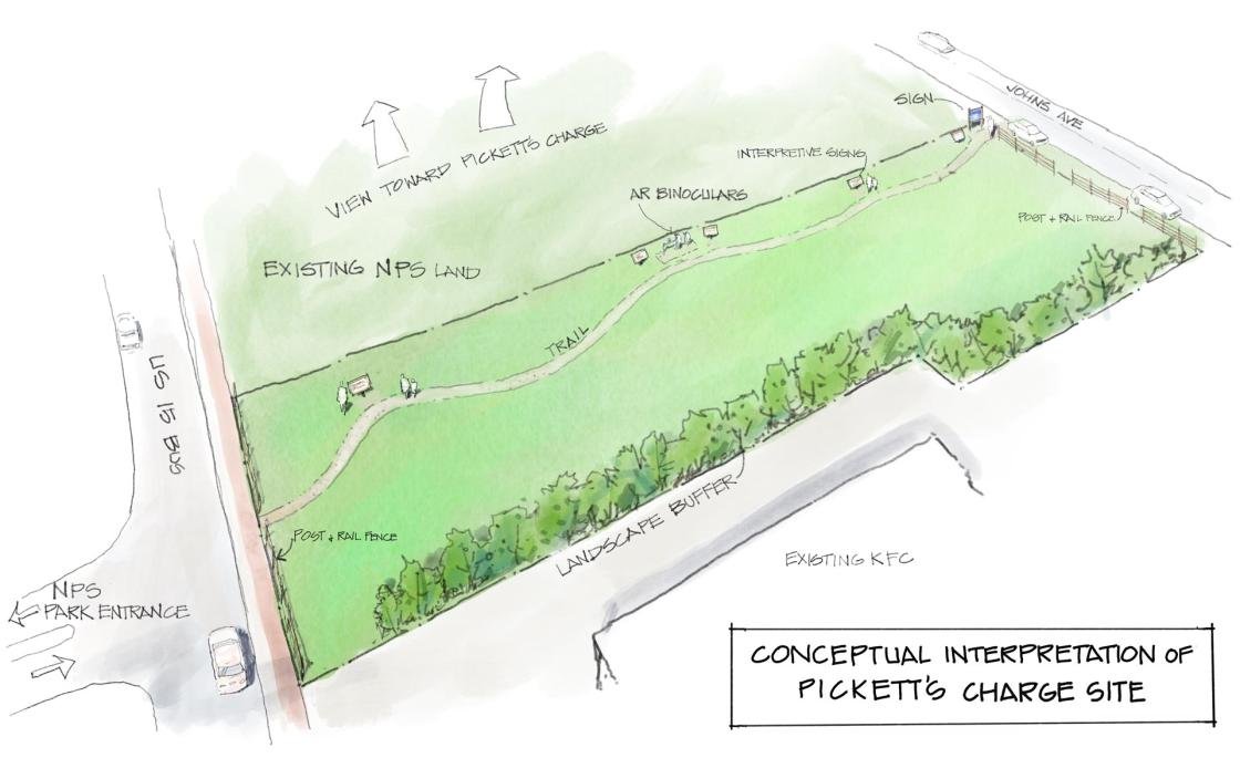
For generations, this half-acre property that played a major role in Pickett’s Charge has been occupied by commercial development, operating as a restaurant, theater, and gift shop known as “General Pickett’s Buffet.” Now, the business is looking to its next chapter – relocating to a new, larger site – and and giving the Trust the opportunity to buy and restore the property.

The Opportunity 

We have an unparalleled preservation opportunity to help save a piece of Gettysburg Battlefield that witnessed monumental points in history, including Pickett’s Charge and two World War camps! The long-time owner of the property has chosen to work with another local businessman to relocate the business several miles away and off the battlefield. We are fortunate that in this process, he approached the Trust about preservation options for the original restaurant site.

It’s a true win-win for everyone: more preserved battlefield and a beloved institution thriving in a new location, retaining local jobs and accommodating even more customers. But if we are unable to come up with the money — in this case, $1.5 million — he will be forced to sell to someone else.

An artist's rendering of a conceptual interpretation of the target property. Dale Watson

In addition to the $1.5 million price tag, we estimate that it will cost another $155,000 to take down the current structure, remove the asphalt parking lot, and restore the landscape, preparing the property for an interpretation and visitor experience that will attract heritage tourists for years to come.

The good news is that this land is eligible for a whopping $750,000 in federal matching funds. Fortunately, we already have half that amount either pledged or in hand from anonymous donors and our great partner organization, the Gettysburg Foundation!

The bottom line is that we still need to raise $550,000 between now and December 15 to ensure that we can close on the property and then have the funds on hand to begin the restoration and interpretation of the property once the federal matching grant is received.

Developers are desperate to scoop up this land. The landowner prefers to sell to us. But we need to raise $550,000 before December 15. Please give now and your donation will be TRIPLED!

Donate Now

The History

While this tract of land at Pickett’s Buffet is small, it has witnessed an unbelievable amount of history.

On the First Day of the Battle of Gettysburg, Union cavalry and then Union infantry galloped or double-quicked to the sound of the guns right past this land, only to be driven back on the same roads later that day to the relative safety of Cemetery Hill where they made their stand.

From this tract on the next day, you would have been able to watch as Confederates swept across the farm fields and Emmittsburg Road to attack the Union III Corps of General Daniel Sickles in the Peach Orchard and the Wheatfield and could have seen battle smoke and heard the distant fighting for Little Round Top. There was also skirmishing on this very land, as the Confederates probed the Union defenses for any advantage.

Gettysburg | Pickett's Charge | July 3, 1863 | 3:45 - 4:00 pm (May 2022) American Battlefield Trust

On the fateful Third Day, from this tract of land you would have had a front-row seat to one of the largest and most significant charges of the entire Civil War.

By the end of those three days, 51,000 soldiers would either lie dead on the battlefield, be wounded (some lightly, many more grievously), become prisoners, or go missing, perhaps never to be seen again.

This land witnessed so much more history! In November of 1863, you would have seen crowds arriving on Cemetery Hill to see and hear President Lincoln deliver one of the most famous speeches in American history, the Gettysburg Address — speaking words that he had written only the night before.

Years later, in 1917, new-fangled weapons of war called “tanks” rumbled across the battlefield. What is now the restaurant’s parking lot was the location of the headquarters of the Camp of the United States Troops at Gettysburg (later dubbed Camp Colt), which was one of 34 WWI training camps in the United States. A young officer named Dwight David Eisenhower was put in command here in 1918, and he would come to love the battlefield and town of Gettysburg, eventually making it his home, which you can still visit today.

Years later, there was also a prisoner of war camp for German WWII POWs, on the same land as the training camp.

Help save a piece of land at Gettysburg that witnessed monumental points in history, including Pickett’s Charge and two World War camps!

From every point on the compass, this small parcel of ground has been a unique witness-place of American history. And today, you and I have the chance to reclaim it, restore it, and preserve its stories forever for our grandchildren and great-grandchildren.

Will you join in this urgent effort by making a gift today?

Donate Now

Help Save 56 Acres of Second Fredericksburg Battlefield

Help Save 56 Acres of Second Fredericksburg Battlefield

Central Virginia Battlefields Trust is collaborating with Downtown Greens, a not-for-profit organization whose mission is to foster community involvement and growth through collaborative environmental stewardship and experiential education, to save 56 acres of farmland in the Battlefield Industrial Park in Fredericksburg. This property contains wetlands, mature timber, and nearly 20 acres of the last working agricultural space in the city. This land is also important hallowed ground where troops from the Army of the Potomac's VI Corps marched and took fire from Confederates along the Howison Hill and Telegraph Hill ridgeline on May 3, 1863. These acres will also provide an important access and future interpretation point for visitors to learn more about the often forgotten story of the Second Battle of Fredericksburg.

Yes, Let's Save Second Fredericksburg Acres!

The Vermont Brigade

During the Battle of Second Fredericksburg, May 3, 1863, regiments from the Army of the Potomac's Vermont Brigade marched and fought across the land that CVBT and Downtown Greens are working to preserve. Organized in 1861, the Vermont Brigade earned an early reputation for tenacity during the Peninsula Campaign and Seven Days' Battles. Possessing excellent leadership and determined soldiers, the Vermont Brigade continued to prove itself during the Overland, 1864 Shenandoah Valley, Petersburg, and Appomattox Campaigns.

Among the Vermont Brigade units to march across the ground that CVBT seeks to preserve with Downtown Greens were the 2nd, 3rd, 4th, and 6th Vermont Infantry regiments. In a letter to his parents following the battle, Pvt. Hiram H. Tilley, 2nd Vermont, explained, "We charged across the open field to the foot of the Heights where we had to cross 'as best we could' a wide ditch partly full of of muddy water after which 'under a heavy fire of muskets' we charged up the Heights. . . ."

Today's fundraising effort will help CVBT continue to fulfill its mission to preserve this area's battlefield land and tell the stories of the soldier's who fought there.

Donate

Gettysburg Battlefield Preservation AssociationPurchases Land for NMP

Battlefield Preservation Association purchases land, will gift to Park Service

Partners stand at the former Crouse property on Route 116, Hanover Road, Straban Township.

November 17, 2022 by Alex J. Hayes

The Gettysburg National Military Park will soon have more land thanks to the Gettysburg Battlefield Preservation Association.

The association recently purchased 50 acres of land across the road from the Historic Daniel Lady Farm on Route 116, Hanover Road, in Straban Township. Melvin Crouse, the land’s previous owner, valued preservation over development.

“I didn’t want a strip mall or condos to be built on such beautiful land,” said Mr. Crouse. “I know Kirk (Davis, GBPA president) and the GBPA will take excellent care of the place”.

Crouse has been a longtime friend of the association and allowed it to use the land for event parking.

“We were approached with an amazing opportunity,” Davis said. “With the help of several principal people at Members 1st Credit Union, we were able to make it happen.”

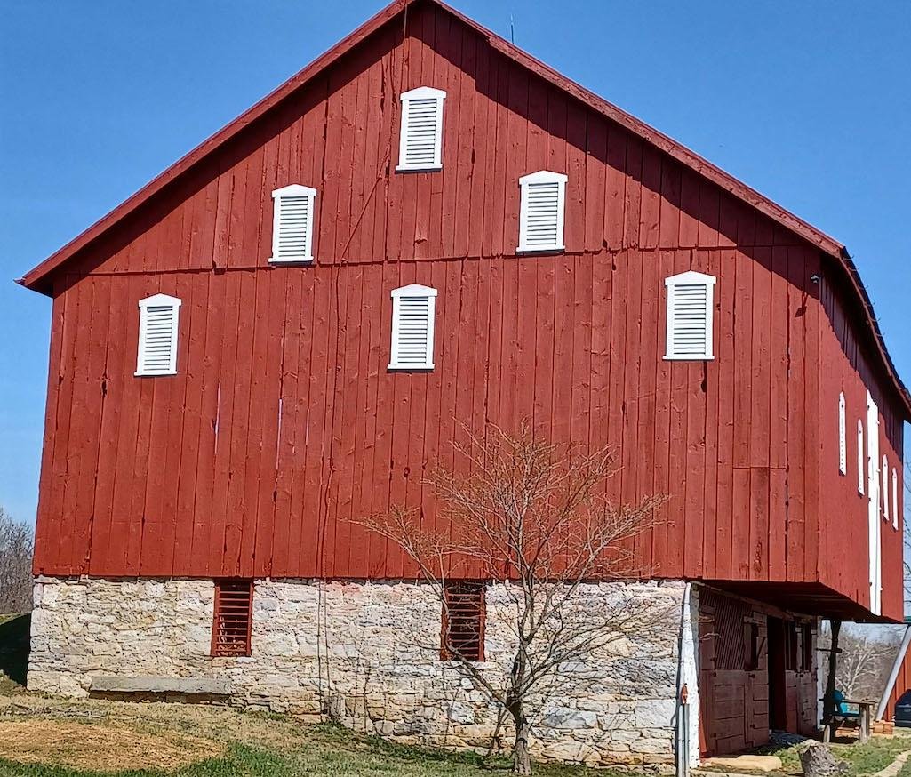
Research done by GBPA shows that a large part of the property was part of the Lady Farm during the Battle of Gettysburg. The acquisition also includes Wolf Hill, a key location for the battle. Adjacent to Culp’s Hill, Wolf Hill was where Major General Edward Johnson arranged his men for battle in a ravine that continued to Benner’s Run. General Johnson used the Daniel Lady Farm as his headquarters and it was a Confederate Field Hospital during the battle.

Founded in 1959, the GBPA has contributed about 200 acres to the National Park Service.

The Daniel Lady Farm was purchased in 1999 with the intention of donating it and the 150 acres around it to the park. The GBPA spent the next several years restoring the house and barn only to find out the National Park Service could not accept it because it was not contiguous with the park’s borders.

The GBPA chose to maintain the property, giving tours and eventually holding events to pay for the necessary expenses. Under Davis, the GBPA was able to obtain the property between the Farm and Benner Hill which now makes it contiguous The purchase of the Crouse property will help complete the story of the battle at Culp’s Hill and the contribution of the Daniel Lady Farm.

“Unfortunately, the National Park cannot accept property with any encumbrances,” says Davis. “We are very grateful to re-enactors and the public who participate in our events and fundraisers. That is even more important now that we have a mortgage that needs to be paid before we can start the turnover process.”

The next large event scheduled to be held at the Lady Farm will be the 160th Anniversary of the Battle of Gettysburg on June 30, July 1 and 2, 2023. Tickets to that event and a list of all GBPA events can be found on the Events page of gbpa.org or danielladyfarm.com. Donations can also be made online or mailed to GBPA, P O Box 4087, Gettysburg, PA, 17325.

Civil War Battlefield Acreage In Mississippi, Virginia, And West Virginia To Be Protected

From National Park Traveler

The Faraway Farm barn witnessed the 1862 Battle of Shepherdstown in West Virginia. The Battlefield Land Acquisition Grant ensures that Faraway Farm remains as it has for the past 160 years/American Battlefield Trust

By Compiled From N... - November 19th, 2022

The Faraway Farm barn witnessed the 1862 Battle of Shepherdstown in West Virginia. The Battlefield Land Acquisition Grant ensures that Faraway Farm remains as it has for the past 160 years/American Battlefield Trust

More than 200 acres of Civil War battlefield acreage in Mississippi, Virginia, and West Virginia are going to be protected thanks to nearly $2 million Battlefield Land Acquisition Grants.

These projects support collaborations among state and local governments and their nonprofit partners to care for the places and stories of the nation's shared heritage. The awards from the National Park Service are made possible by the Land and Water Conservation Fund, which reinvests revenue from offshore oil and natural gas leasing to help strengthen conservation and recreation opportunities across the nation. 

One of the grants announced Friday goes to the Jefferson County Landmarks Commission and will support the purchase and placement of a perpetual conservation easement on nearly 122 acres of the Shepherdstown Battlefield in Jefferson County, West Virginia. The project brings together the county government, a local landowner, the Land Trust of the Eastern Panhandle, and the nonprofit American Battlefield Trust to ensure that the fields of Faraway Farm remain as they have been for much of the past 160 years.  

In late September 1862, after the Union army beat back the Confederate invasion of Maryland at Antietam, General Robert E. Lee retreated across the Potomac and left a rearguard to defend the river’s ford. Union troops suffered heavy casualties in crossing the river and trying to establish a beachhead. This rearguard action halted Federal pursuit of the retreating Confederates and cost Union Major General George McClelland his job, but the Union victory at the end of the Maryland campaign was the “turning point” that President Abraham Lincoln was seeking.

On September 22, 1862, President Abraham Lincoln issued the Preliminary Emancipation Proclamation, with the promise of forever freedom to persons held in slavery in secessionist states at the stroke of the new year. The grant builds on sustained preservation efforts that have protected more than 600 acres at Shepherdstown and on our collective commitment to healing and renewal. 

The other grant awards went to: 

The Battlefield Land Acquisition Grants managed by the National Park Service empower preservation partners nationwide to acquire and preserve threatened battlefields on American soil. In addition, the program administers three other grant programs: Preservation PlanningBattlefield Interpretation and Battlefield Restoration grants. Financial and technical assistance support sustainable, community-driven stewardship of natural and historic resources at the state, tribal and local levels. 

Protect Missouri’s Civil War Battlefields

Missouri played a pivotal role in the American Civil War; only Virginia and Tennessee saw more fighting and more battles than the “Show-Me” State. In the southwestern corner of the state, combat that would determine whether Missouri would be a Union or Confederate stronghold played out on key battlefields. Wilson’s Creek National Battlefield protects the site of such an engagement in August 1861, but the issue was hardly decided in one day.

  Two crucial Civil War battles were fought in and around the small community of Newtonia, Missouri, a short distance from the battlefield at Wilson’s Creek, that helped to decide the state’s fate in the war. The first, fought in September 1862, was among the very few Civil War engagements that included Native Americans fighting on both sides. The second battle at Newtonia in October 1864 was the last major engagement of the Civil War in Missouri.

  Legislation to expand the boundaries of Wilson’s Creek National Battlefield to incorporate the site of these engagements has been introduced by Senator Roy Blunt and Representative Billy Long (S3307 and HR6130). While this boundary expansion does not immediately bring preserved lands at Newtonia into the national park, it is the critical first step that makes such a transfer possible. We encourage you to support these bills to ensure this part of American history is protected in perpetuity by the National Park Service.

The inclusion of these critical acres inside the National Park System has the support of the Newtonia Battlefields Protection Association, the Wilson's Creek National Battlefield Foundation and the American Battlefield Trust. To date, 25 acres have been preserved by local preservation groups, including the historic Ritchie House, one of the few remaining structures to witness the battle. The Trust is proud to have been involved in that transaction.

  The fate of this legislation will be decided by the end of the year, so please take a moment to visit our Speak Out page and contact your legislators now. Time is especially precious because Senator Blunt, a longtime advocate for the national park and battlefield preservation in general, is retiring when his term concludes in early January.

  Your voice matters: Help us secure the future of these important battlefield lands and ensure a fuller interpretation of related historical events within the park. Send a letter to your legislators today.

 Sincerely,

Jim Campi, Chief Policy and Communications Officer

American Battlefield Trust

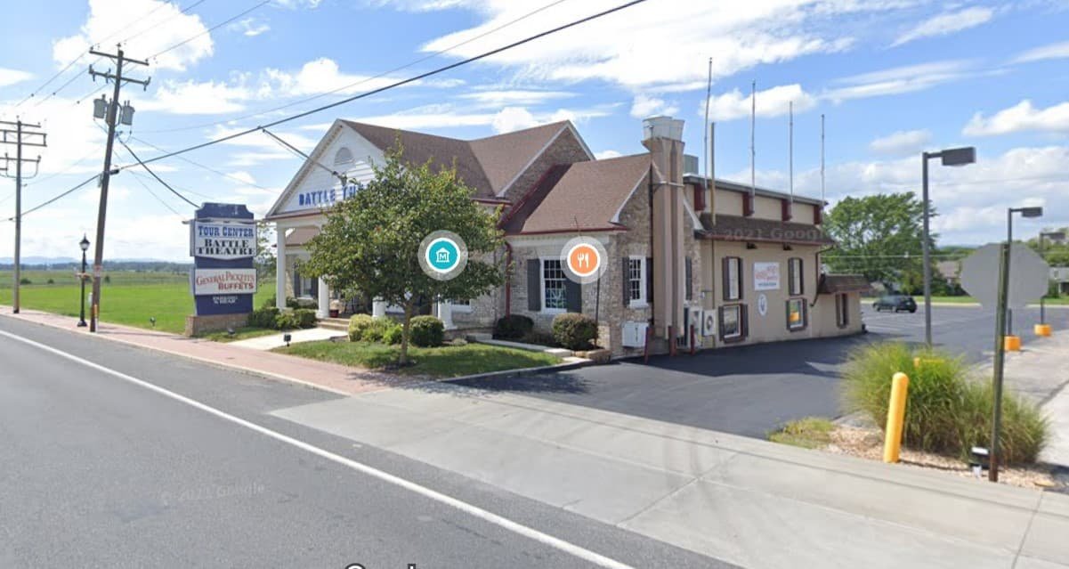
American Battlefield Trust hopes to purchase General Pickett’s Buffet in Gettysburg

American Battlefield Trust hopes to purchase General Pickett’s Buffet

November 9, 2022 by Leon Reed

Google Image

In the first major land preservation action in the core area of the of the Gettysburg battlefield since the 2003 demolition of the Home Sweet Home Motel, the American Battlefield Trust (ABT) plans to purchase the site of General Pickett’s Buffet Restaurant located on the southern edge of Gettysburg at 571 Steinwehr Avenue. The site is also home to the Gettysburg Battlefield Theater.

The ABT, formerly known as the Civil War Trust, is a charitable organization that has acquired and preserved over 50,000 acres of battlefields of the American Civil War, the Revolutionary War and the War of 1812.

“For generations, this half-acre property that played a major role in Pickett’s Charge has been compromised by commercial development, operating as a restaurant, theater, and gift shop known as General Pickett’s Buffet. Now, the long-time owner has decided to retire and give the Trust the opportunity to buy and restore the property,” said an announcement on the ABT website

General Pickett’s is a longtime popular restaurant that has provided meals to untold numbers of bus tourists. But it was also one of the most intrusive commercial presences on the battlefield, plainly visible by any visitor standing at the Angle or leaving the National Cemetery from the Taneytown Rd. exit, for example. It is also land where pivotal action of Pickett’s Charge took place.

The move drew high marks from historians and preservationists.

“When George Pickett tried to rally his men for their charge across the field toward the Union line, he certainly said, ‘Some day, future generations will honor your courage and sacrifice on this battlefield with an all-you-can-eat buffet!’ Of course he didn’t—but that’s part of what has made General Pickett’s Buffet such a surreal part of the Gettysburg landscape,” said Chris Mackowski, author of five books on Gettysburg. “It has become such a well-known landmark, but it’s jarring in its juxtaposition. Reclaiming that part of the battlefield, in the context of the reclamation that has gone on directly across the street, will help restore the hallowed nature of the ground where this fabled story took place.”

Mackowski said he was speaking as an individual.

“It is hard to think of a more important parcel on the battlefield to be preserved. This is a natural follow-up to the acquisition and reclamation of the adjacent Home Sweet Home motel property two decades ago,” said licensed guide and author Ralph Siegel, who said he was speaking as an individual.

It is likely that this property will be transferred to the Gettysburg National Military Park once it has been cleared and rehabilitated.

Featured image from Google Maps.

Firing the First Shot of the American Civil War at Fort Johnson

Have you heard about our latest preservation opportunity to purchase three battlefield tracts spanning three wars?

  Three parcels of land totaling almost seven acres — with history spanning the French and Indian War, the Revolutionary War, and the beginning shots of the Civil War — must be preserved and we must act fast to save it.

  Watch a video Kristopher White recorded for you from the battlefield!

[VIDEO] Click here to join us for a 9-minute overview.

  Thanks to generous local grants, as well as commitments from a major donor and private landowners, the amount we need to raise for these three parcels is just $62,000 of the total $2.7 million.

  Each of these transactions will allow us to add to existing protected lands and preserve them for future generations, while making progress toward our ambitious goal of saving 2,500 acres of Revolutionary War battlefields to mark the conflict’s 250th anniversary!

  Your Gift Matched $45-to-$1! That means every $1 you give is worth $45 with these matching grants. Securing these properties is well within reach with your help. Please make a donation today.

  Will you join us in protecting hallowed ground at Fort Johnson, South Carolina, Eutaw Springs, South Carolina, and Fort Ticonderoga, New York? Your gift will be matched $45-to-$1!

  Thank you for everything you do to preserve America's hallowed ground.

 With warmest regards,

 Garry Adelman, Chief Historian

American Battlefield Trust